Difference between revisions of "2023-03-07 47 8"
From Geohashing
Globescorer (talk | contribs) (→Plans) |
Globescorer (talk | contribs) (→Expedition) |
||
| Line 11: | Line 11: | ||
==Expedition== | ==Expedition== | ||
| + | |||
| + | ==Gallery== | ||
| + | <gallery> | ||
| + | File:2023-03-07 47 8 mule.jpg |The mules | ||
| + | File:2023-03-07 47 8 way to go.jpg |Way to go | ||
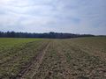
| + | File:2023-03-07 47 8 The Geohash.jpg |The Geohash | ||
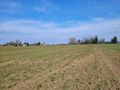
| + | File:2023-03-07 47 8 south.jpg |south | ||
| + | File:2023-03-07 47 8 west.jpg |west | ||
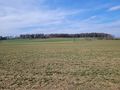
| + | File:2023-03-07 47 8 north.jpg |north | ||
| + | File:2023-03-07 47 8 east.jpg |east | ||
| + | File:2023-03-07 47 8 The Hasher.jpg |Me | ||
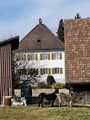
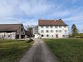
| + | File:2023-03-07 47 8 castle 1.jpg |The castle south | ||
| + | File:2023-03-07 47 8 castle 2.jpg |The castle north | ||
| + | </gallery> | ||
| + | |||
[[Category:Expedition planning]] | [[Category:Expedition planning]] | ||
{{location|CH|TG}} | {{location|CH|TG}} | ||
Revision as of 20:17, 7 March 2023
| Tue 7 Mar 2023 in 47,8: 47.6335445, 8.9437915 geohashing.info google osm bing/os kml crox |
Contents
Location
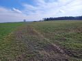
The hashpoint is located in a field near the very small village Gündelhart TG (Switzerland)
Participants
Plans
After Lunch in my free afternoon I will drive to Gündelhart and back as a tron. For this I take my Motorcycle the first time this year for a ride (like a TRON :-) I will be there at about 2 o'clock in the afternoon. And I will visit there the former castle Gündelhart which is today a farm estate and also the nearby church.
Expedition
Gallery
The mules
Way to go
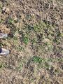
The Geohash
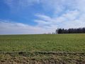
south
west
north
east

Me
The castle south
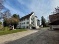
The castle north


