Difference between revisions of "2023-04-06 47 8"
From Geohashing
Globescorer (talk | contribs) (→Gallery) |
Globescorer (talk | contribs) (→Gallery) |
||
| Line 28: | Line 28: | ||
File:2023-04-06 47 8 temperature proof.jpg |temperature proof | File:2023-04-06 47 8 temperature proof.jpg |temperature proof | ||
</gallery> | </gallery> | ||
| + | |||
| + | == Ribbons == | ||
| + | {{Frozen Geohash | latitude = 47 | longitude = 8 | date = 2023-04-06 | name = globescorer |image=2023-04-06 47 8 temperature proof.jpg}} | ||
| + | {{land geohash|date=2023-04-06|latitude=47|longitude=8|name=[[User:globescorer|globescorer]]|image=2023-04-06 47 8 The Geohash.jpg}} | ||
Revision as of 12:32, 6 April 2023
| Thu 6 Apr 2023 in 47,8: 47.5180172, 8.4607676 geohashing.info google osm bing/os kml crox |
Location
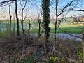
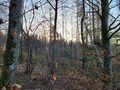
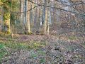
The hashpoint is located at the edge of the forest in the community Stadel (ZH)

Participants
Plans
--
Expedition
Before work i wanted to visit this geohash. So I drove to a parking lot outside of Stadel and walked to the coordinates, which are only 2m from the path in the forest. I took my photos and evidence at the coordinates. After that I carved the XKCD sign on the path and took another picture of the view there. Then i walked back and drove to work... Nice trip with a great sunrise after a wonderful full moon night with cold temperatures (-2°)!
Gallery
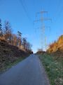
way to go
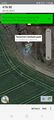
The Geohash
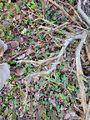
The Proof 1
The Proof 2
west
southeast
northeast
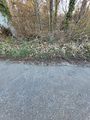
XKCD-sign
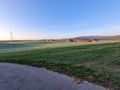
surroundings
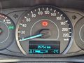
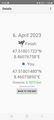
temperature proof


Ribbons

globescorer earned the Frozen Geohash Achievement
by reaching the (47, 8) geohash on 2023-04-06 while the temperature was below the freezing point of water.
globescorer earned the Land geohash achievement
|