Difference between revisions of "2023-06-24 51 4"
FelixTheCat (talk | contribs) (Created page with "{{subst:Expedition |lat = 51 |lon = 4 |date = 2023-06-24 }}") |
FelixTheCat (talk | contribs) |
||
| Line 1: | Line 1: | ||
| − | + | {{meetup graticule | |
| − | |||
| − | |||
| − | |||
| − | |||
| − | |||
| − | |||
| − | |||
| − | |||
| lat=51 | | lat=51 | ||
| lon=4 | | lon=4 | ||
| date=2023-06-24 | | date=2023-06-24 | ||
| − | }} | + | }} |
== Location == | == Location == | ||
| − | + | Next to the Moerdijk bridge, North Brabant province. | |
== Participants == | == Participants == | ||
| − | + | [[User:FelixTheCat|FelixTheCat]] ([[User talk:FelixTheCat|talk]]) | |
| − | |||
| − | |||
| − | |||
| − | |||
== Expedition == | == Expedition == | ||
| − | + | Today's point was on public land, right next to a wide river known as Hollands Diep. There are two bridges nearby which connect North Brabant province in the south to South Holland province in the north. The point was also reasonably close to a train station, so I decided to use public transport. Normally this would be a one-hour trip from Delft to Lage Zwaluwe, changing trains either in Rotterdam or Dordrecht. This weekend however, there was scheduled maintenance on the train tracks around Rotterdam Central station and I had to take a rail replacement bus from Schiedam to Rotterdam Stadion, adding half an hour to the trip. Once I arrived at Lage Zwaluwe I rented a bike and rode to the point. It was on a dead-end street next to a field. I found the point and took the required pictures. I then had a look at the Moerdijk Bridge Monument and rode on to the village of Moerdijk, after which I continued back to the train station. I took the same train-bus-train route back home. | |
| − | + | During this trip I visited two train stations that I haven't really been to before. Rotterdam Stadion (with a "d", meaning "stadium" rather than "station") is a special station that's normally only used to ferry fans to the Feyenoord football stadium next door when there's a match, and is otherwise unused. Lage Zwaluwe is famous for being a rather large train station sitting in the middle of nowhere, about five kilometres away from the village of the same name. I think the main reason this station was built was to create a connection between the Rotterdam-Breda line and the line coming from Antwerp; I remember having to change trains here when coming back from Belgium many years ago. | |
| − | |||
== Photos == | == Photos == | ||
| − | |||
| − | |||
| − | |||
<gallery perrow="5"> | <gallery perrow="5"> | ||
| + | Image:2023-06-24 51 4 FelixTheCat 1.JPG | Rotterdam Stadion has an interesting display with what looks like hand-made neon signs that indicate the destination of the trains. Our train towards Roosendaal is on the left. | ||
| + | Image:2023-06-24 51 4 FelixTheCat 2.JPG | We're crossing Hollands Diep. It's over a kilometre wide, so a more appropriate name would have been "Hollands Breed". | ||
| + | Image:2023-06-24 51 4 FelixTheCat 3.JPG | We're at Lage Zwaluwe railway station. Note how many tracks and platforms there are, despite the only things nearby being fields and wind turbines. | ||
| + | Image:2023-06-24 51 4 FelixTheCat 4.JPG | There aren't many facilities either, but luckily there is an automated bike rental system. | ||
| + | Image:2023-06-24 51 4 FelixTheCat 5.JPG | Riding towards the hash, we can spot the Moerdijk Bridge monument in the distance. There's also a small aeroplane flying by while towing a banner. | ||
| + | Image:2023-06-24 51 4 FelixTheCat 6.JPG | Apparently someone just had a baby and wanted to share this with the world. | ||
| + | Image:2023-06-24 51 4 FelixTheCat 7.JPG | The hash is just by the side of this dead-end road next to the freight railway line. | ||
| + | Image:2023-06-24 51 4 FelixTheCat 8.JPG | There's lots of unfriendly plants. Luckily I wasn't wearing shorts. | ||
| + | Image:2023-06-24 51 4 FelixTheCat 9.png | GPS proof. | ||
| + | Image:2023-06-24 51 4 FelixTheCat 10.JPG | Lloyd and Trix celebrating. | ||
| + | Image:2023-06-24 51 4 FelixTheCat 11.JPG | Looking north-west. | ||
| + | Image:2023-06-24 51 4 FelixTheCat 12.JPG | Looking north-east. | ||
| + | Image:2023-06-24 51 4 FelixTheCat 13.JPG | A freight train approaches. | ||
| + | Image:2023-06-24 51 4 FelixTheCat 14.JPG | The Moerdijk Bridge monument up close. | ||
</gallery> | </gallery> | ||
== Achievements == | == Achievements == | ||
{{#vardefine:ribbonwidth|100%}} | {{#vardefine:ribbonwidth|100%}} | ||
| − | + | {{Public transport geohash | |
| − | + | | latitude = 51 | |
| + | | longitude = 4 | ||
| + | | date = 2023-06-24 | ||
| + | | busline = train, rail replacement bus and rental bike | ||
| + | | name = [[User:FelixTheCat|FelixTheCat]] ([[User talk:FelixTheCat|talk]]) | ||
| + | }} | ||
__NOTOC__ | __NOTOC__ | ||
<!-- =============== USEFUL CATEGORIES FOLLOW ================ | <!-- =============== USEFUL CATEGORIES FOLLOW ================ | ||
| − | |||
| − | |||
| − | |||
| − | |||
| − | |||
| − | |||
| − | |||
| − | |||
| − | |||
| − | |||
| − | |||
| − | |||
| − | |||
[[Category:Expeditions]] | [[Category:Expeditions]] | ||
| − | |||
[[Category:Expeditions with photos]] | [[Category:Expeditions with photos]] | ||
| − | |||
| − | |||
| − | |||
| − | |||
| − | |||
[[Category:Coordinates reached]] | [[Category:Coordinates reached]] | ||
| − | |||
| − | |||
| − | |||
| − | |||
| − | |||
| − | |||
| − | |||
| − | |||
| − | |||
| − | |||
| − | |||
| − | |||
| − | |||
| − | |||
| − | |||
| − | |||
| − | |||
| − | |||
Revision as of 10:00, 25 June 2023
| Sat 24 Jun 2023 in 51,4: 51.7112727, 4.6458125 geohashing.info google osm bing/os kml crox |
Location
Next to the Moerdijk bridge, North Brabant province.
Participants
Expedition
Today's point was on public land, right next to a wide river known as Hollands Diep. There are two bridges nearby which connect North Brabant province in the south to South Holland province in the north. The point was also reasonably close to a train station, so I decided to use public transport. Normally this would be a one-hour trip from Delft to Lage Zwaluwe, changing trains either in Rotterdam or Dordrecht. This weekend however, there was scheduled maintenance on the train tracks around Rotterdam Central station and I had to take a rail replacement bus from Schiedam to Rotterdam Stadion, adding half an hour to the trip. Once I arrived at Lage Zwaluwe I rented a bike and rode to the point. It was on a dead-end street next to a field. I found the point and took the required pictures. I then had a look at the Moerdijk Bridge Monument and rode on to the village of Moerdijk, after which I continued back to the train station. I took the same train-bus-train route back home.
During this trip I visited two train stations that I haven't really been to before. Rotterdam Stadion (with a "d", meaning "stadium" rather than "station") is a special station that's normally only used to ferry fans to the Feyenoord football stadium next door when there's a match, and is otherwise unused. Lage Zwaluwe is famous for being a rather large train station sitting in the middle of nowhere, about five kilometres away from the village of the same name. I think the main reason this station was built was to create a connection between the Rotterdam-Breda line and the line coming from Antwerp; I remember having to change trains here when coming back from Belgium many years ago.
Photos
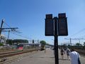
Rotterdam Stadion has an interesting display with what looks like hand-made neon signs that indicate the destination of the trains. Our train towards Roosendaal is on the left.
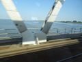
We're crossing Hollands Diep. It's over a kilometre wide, so a more appropriate name would have been "Hollands Breed".
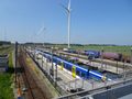
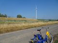
We're at Lage Zwaluwe railway station. Note how many tracks and platforms there are, despite the only things nearby being fields and wind turbines.
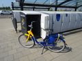
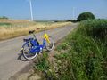
There aren't many facilities either, but luckily there is an automated bike rental system.
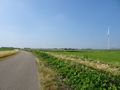
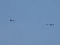
Riding towards the hash, we can spot the Moerdijk Bridge monument in the distance. There's also a small aeroplane flying by while towing a banner.
Apparently someone just had a baby and wanted to share this with the world.
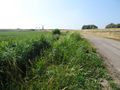
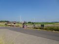
The hash is just by the side of this dead-end road next to the freight railway line.
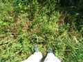
There's lots of unfriendly plants. Luckily I wasn't wearing shorts.
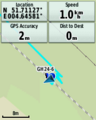
GPS proof.
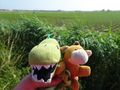
Lloyd and Trix celebrating.
Looking north-west.
Looking north-east.
A freight train approaches.
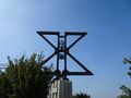
The Moerdijk Bridge monument up close.


Achievements
FelixTheCat (talk) earned the Public transport geohash achievement
|