Difference between revisions of "2023-07-28 34 -118"
(Created page with "{{subst:Expedition}}") |
(→Photos) |
||
| (4 intermediate revisions by 3 users not shown) | |||
| Line 14: | Line 14: | ||
== Location == | == Location == | ||
<!-- where you've surveyed the hash to be --> | <!-- where you've surveyed the hash to be --> | ||
| + | Right near the trailhead of Sycamore Canyon Trail in [[wikipedia:Whittier, California|Whittier]], just about bordering the expansive Rose Hills Memorial Park (cemetery) to the north. | ||
== Participants == | == Participants == | ||
<!-- who attended: If you link to your wiki user name in this section, your expedition will be picked up by the various statistics generated for geohashing. You may use three tildes ~ as a shortcut to automatically insert the user signature of the account you are editing with. | <!-- who attended: If you link to your wiki user name in this section, your expedition will be picked up by the various statistics generated for geohashing. You may use three tildes ~ as a shortcut to automatically insert the user signature of the account you are editing with. | ||
--> | --> | ||
| + | [[User:LB-FT|LB-FT]] ([[User talk:LB-FT|talk]]) | ||
== Plans == | == Plans == | ||
<!-- what were the original plans --> | <!-- what were the original plans --> | ||
| + | The point is located in the parking area serving the start point of a hiking trail, how convenient! I don't think I'll have time to explore the trail itself today, however. | ||
== Expedition == | == Expedition == | ||
<!-- how it all turned out. your narrative goes here. --> | <!-- how it all turned out. your narrative goes here. --> | ||
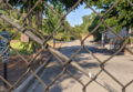
| + | I drove to the destination but found the gates about 100 meters away from the point closed and locked for the day, presumably at 6:00 p.m. as the signage said. I didn't expect there to be a gate since the aerial map of the place seemed to imply that the trail parking area also allowed access for adjacent homes. | ||
| + | |||
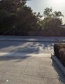
| + | Anyways I parked streetside nearby and walked to the gate as close to the point as I could reach and snapped a few photos. During the short walk from car to gate, I found 3 quarters on the dirt "sidewalk" and then another quarter (with a small chunk sheared off) that I missed the first time, when I came back to the spot after realizing I could take a picture to accompany my little story on here. | ||
== Tracklog == | == Tracklog == | ||
| Line 33: | Line 39: | ||
--> | --> | ||
<gallery perrow="5"> | <gallery perrow="5"> | ||
| + | 2023-07-28_34_-118_proof.png | Proof of closest approach | ||
| + | 2023-07-28_34_-118_point.png | Hashpoint is at center, a meter or so past the parking lot edge | ||
| + | 2023-07-28_34_-118_lookingwest.jpg | Looking west from the locked gate | ||
| + | 2023-07-28_34_-118_signclosed.png | Does this count as for no-trespassing ribbon? | ||
| + | 2023-07-28_34_-118_dollar.jpg | Failed geohash consolation prize | ||
</gallery> | </gallery> | ||
| Line 40: | Line 51: | ||
__NOTOC__ | __NOTOC__ | ||
| − | |||
| − | |||
| − | |||
| − | |||
| − | |||
| − | |||
| − | |||
| − | |||
| − | |||
| − | |||
| − | |||
| − | |||
| − | |||
| − | |||
[[Category:Expeditions]] | [[Category:Expeditions]] | ||
| − | |||
[[Category:Expeditions with photos]] | [[Category:Expeditions with photos]] | ||
| − | |||
| − | |||
| − | |||
| − | |||
| − | |||
| − | |||
| − | |||
| − | |||
| − | |||
[[Category:Coordinates not reached]] | [[Category:Coordinates not reached]] | ||
| − | |||
| − | |||
| − | |||
| − | |||
| − | |||
[[Category:Not reached - No public access]] | [[Category:Not reached - No public access]] | ||
| − | + | {{location|US|CA|LO}} | |
| − | |||
| − | |||
| − | |||
| − | |||
| − | |||
| − | |||
| − | |||
Revision as of 08:09, 19 November 2023
| Fri 28 Jul 2023 in 34,-118: 34.0041507, -118.0547343 geohashing.info google osm bing/os kml crox |
Location
Right near the trailhead of Sycamore Canyon Trail in Whittier, just about bordering the expansive Rose Hills Memorial Park (cemetery) to the north.
Participants
Plans
The point is located in the parking area serving the start point of a hiking trail, how convenient! I don't think I'll have time to explore the trail itself today, however.
Expedition
I drove to the destination but found the gates about 100 meters away from the point closed and locked for the day, presumably at 6:00 p.m. as the signage said. I didn't expect there to be a gate since the aerial map of the place seemed to imply that the trail parking area also allowed access for adjacent homes.
Anyways I parked streetside nearby and walked to the gate as close to the point as I could reach and snapped a few photos. During the short walk from car to gate, I found 3 quarters on the dirt "sidewalk" and then another quarter (with a small chunk sheared off) that I missed the first time, when I came back to the spot after realizing I could take a picture to accompany my little story on here.
Tracklog
Photos
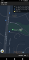
Proof of closest approach
Hashpoint is at center, a meter or so past the parking lot edge
Looking west from the locked gate
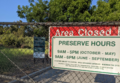
Does this count as for no-trespassing ribbon?
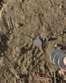
Failed geohash consolation prize


