Difference between revisions of "2023-08-25 42 -86"
From Geohashing
Bwest31415 (talk | contribs) |
Bwest31415 (talk | contribs) (→Photos) |
||
| Line 28: | Line 28: | ||
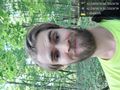
Stupid grin! ✅️ [https://openstreetmap.org/?mlat=42.24096260&mlon=-86.32634140&zoom=16 @42.2410,-86.3263] | Stupid grin! ✅️ [https://openstreetmap.org/?mlat=42.24096260&mlon=-86.32634140&zoom=16 @42.2410,-86.3263] | ||
</gallery> | </gallery> | ||
| − | |||
| − | |||
| − | |||
== Achievements == | == Achievements == | ||
Revision as of 17:07, 28 August 2023
| Fri 25 Aug 2023 in 42,-86: 42.2409597, -86.3263407 geohashing.info google osm bing/os kml crox |
Location
Near the Berrien/Van Buren County line, Michigan
Participants
Plans
Driving out to the spot on the road nearest to the hashpoint, then walk the 800 ft to the hashpoint itself.
Expedition
It was a short drive from work over to the street where the hashpoint was located. I parked on the side of the tiny road and started hoofing it through the woods. It took a lot longer to navigate the terrain than I expected. There was some hill climbing and creek jumping involved...just enough adventure for a first-time geohash.
Photos
First geohash!!
