Difference between revisions of "2023-09-03 42 -70"
From Geohashing
([live picture]Proof.) |
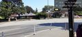
([live picture]The construction in the way. [https://openstreetmap.org/?mlat=42.47275540&mlon=-70.89965520&zoom=16 @42.4728,-70.8997]) |
||
| Line 43: | Line 43: | ||
Image:2023-09-03_42_-70_JesseFTW_1693798460426.jpg|Proof. | Image:2023-09-03_42_-70_JesseFTW_1693798460426.jpg|Proof. | ||
| + | |||
| + | Image:2023-09-03_42_-70_JesseFTW_1693798494688.jpg|The construction in the way. [https://openstreetmap.org/?mlat=42.47275540&mlon=-70.89965520&zoom=16 @42.4728,-70.8997] | ||
</gallery> | </gallery> | ||
Revision as of 03:35, 4 September 2023
| Sun 3 Sep 2023 in 42,-70: 42.4709571, -70.8946800 geohashing.info google osm bing/os kml crox |
Location
Participants
Plans
Expedition
- Drove out to the hash, found we couldn't park nearby. Drove around to what we thought was the street the hash was on, but it didn't connect - there was a park in the way. Got out of the car to walk thru the park... but it was closed due to construction. Got back in the car, drove further, avoiding a bicyclist and people having a conversation in the middle of the road, and parked on a side street about a block from the hash. Walked over, and made it! -- JesseFTW (talk) 23:32, 3 September 2023 (EDT)
Tracklog
Photos

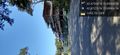
Very neat sculpture at the hash. @42.4711,-70.8947

Silly Grin, as required. @42.4709,-70.8947
View from the hashpoint. @42.4715,-70.8946
Proof.
The construction in the way. @42.4728,-70.8997


Achievements