Difference between revisions of "2023-09-04 41 -88"
Tarasaurus (talk | contribs) (first draft) |
Tarasaurus (talk | contribs) (Final version I think) |
||
| Line 14: | Line 14: | ||
== Expedition == | == Expedition == | ||
| − | + | Today being a public holiday called Labor Day, I was fortunate enough to have the day off from work, and even more fortunate to find the hash point close to home. Close enough in fact that it appeared to be a great chance for my first Walk geohash achievement. So around 8am I packed Sylvie into my pocket, fired up Pokemon Go on my phone, and began the walk to the neighborhood adjacent to the field the point was in. On Google maps it appeared to be in a golf course, so I wasn't super hopeful of being able to get access. | |
| + | However, as I turned down the road that led nearest to the point, I was greeted by numerous signs warning against trespassing and such. Apparently the road I was walking down was not a road at all, but in fact a long driveway to access the North Aurora water tower located here. Also visible was the "field" containing the geohash, which had a suspiciously warehouse shaped building being constructed in it. That didn't seem to bode well for reaching the point, but I remembered seeing another potential access road further away at the other end of the former golf course, so I headed over there. | ||
| + | Upon arriving at said road which led to a fully complete and occupied warehouse building, there was a yellow gate blocking the road and a sign saying "Emergency vehicles only". Past the yellow gate was another gate, and past that was yet another gate. Triple gated. As if one gate wasn't enough to make it clear no entry was allowed. Never before have I been on a geohashing expedition that was so thoroughly denied access as this. | ||
| + | |||
| + | ===Why you should not trust satellite imagery=== | ||
| + | Welcome to Tara's lesson in not trusting everything you see on the internet, particularly when it comes to satellite imagery. You may think, "This is a photo, that was taken of an actual location and has not been digitally manipulated in a malicious way." Well that doesn't mean it is accurate and it may still be very misleading! After my expedition I fired up Google Earth (because it has date controls for imagery) and took these screen shots of the imagery visible for the area of the hash point from this expedition: | ||
| + | <gallery widths=400px heights="250px" perrow=2> | ||
| + | Image:2023-09-04 41 -88 map1.png|Default image, from July 2022 | ||
| + | Image:2023-09-04 41 -88 map2.png|Dated July 2023 | ||
| + | </gallery> | ||
| + | The left image, which is what is displayed by Google products by default, is from July of 2022, over a year previous to today, and depicts what appears to be a golf course in the area. However, it does appear to be to different images blended together in the middle of the course, making it more difficult to tell what the terrain there really looks like. Only when viewing the most recent available images in Google Earth, which are from July 2023, do the current buildings appear. Fortunately, while I was misled by the inaccurate imagery it wasn't dangerous to me in any way. I could simply not access the area. But had this been in particularly difficult terrain it wouldn't be difficult for a geohasher to believe they could adventure into an area that looks safe from the default imagery only to find the actual conditions encountered to be anything but. | ||
| + | |||
| + | Lesson learned, don't trust satellite imagery! Do diligent research before adventuring out. | ||
== Photos == | == Photos == | ||
| − | |||
| − | |||
| − | |||
<gallery perrow="5"> | <gallery perrow="5"> | ||
| + | Image:2023-09-04 41 -88 no1.jpg|No access and visible construction site | ||
| + | Image:2023-09-04 41 -88 no2.jpg|Not just gated, triple gated! (3rd gate out of frame) | ||
</gallery> | </gallery> | ||
== Achievements == | == Achievements == | ||
{{#vardefine:ribbonwidth|100%}} | {{#vardefine:ribbonwidth|100%}} | ||
| − | + | {{No trespassing | |
| − | + | | latitude = 41 | |
| − | + | | longitude = -88 | |
| − | + | | date = 2023-09-04 | |
| + | | name = Tarasaurus | ||
| − | + | }} | |
| − | |||
| − | |||
| − | |||
| − | |||
| − | |||
| − | |||
| − | |||
| − | |||
[[Category:Expeditions]] | [[Category:Expeditions]] | ||
| − | |||
[[Category:Expeditions with photos]] | [[Category:Expeditions with photos]] | ||
| − | |||
| − | |||
| − | |||
| − | |||
| − | |||
| − | |||
| − | |||
| − | |||
| − | |||
[[Category:Coordinates not reached]] | [[Category:Coordinates not reached]] | ||
| − | |||
| − | |||
| − | |||
| − | |||
| − | |||
[[Category:Not reached - No public access]] | [[Category:Not reached - No public access]] | ||
| − | |||
| − | |||
| − | |||
| − | |||
| − | |||
| − | |||
| − | |||
| − | |||
Revision as of 15:22, 4 September 2023
| Mon 4 Sep 2023 in 41,-88: 41.8013033, -88.3392146 geohashing.info google osm bing/os kml crox |
Contents
Location
In a field or golf course in North Aurora.
Participants
Plans
Going to walk there if I can.
Expedition
Today being a public holiday called Labor Day, I was fortunate enough to have the day off from work, and even more fortunate to find the hash point close to home. Close enough in fact that it appeared to be a great chance for my first Walk geohash achievement. So around 8am I packed Sylvie into my pocket, fired up Pokemon Go on my phone, and began the walk to the neighborhood adjacent to the field the point was in. On Google maps it appeared to be in a golf course, so I wasn't super hopeful of being able to get access.
However, as I turned down the road that led nearest to the point, I was greeted by numerous signs warning against trespassing and such. Apparently the road I was walking down was not a road at all, but in fact a long driveway to access the North Aurora water tower located here. Also visible was the "field" containing the geohash, which had a suspiciously warehouse shaped building being constructed in it. That didn't seem to bode well for reaching the point, but I remembered seeing another potential access road further away at the other end of the former golf course, so I headed over there.
Upon arriving at said road which led to a fully complete and occupied warehouse building, there was a yellow gate blocking the road and a sign saying "Emergency vehicles only". Past the yellow gate was another gate, and past that was yet another gate. Triple gated. As if one gate wasn't enough to make it clear no entry was allowed. Never before have I been on a geohashing expedition that was so thoroughly denied access as this.
Why you should not trust satellite imagery
Welcome to Tara's lesson in not trusting everything you see on the internet, particularly when it comes to satellite imagery. You may think, "This is a photo, that was taken of an actual location and has not been digitally manipulated in a malicious way." Well that doesn't mean it is accurate and it may still be very misleading! After my expedition I fired up Google Earth (because it has date controls for imagery) and took these screen shots of the imagery visible for the area of the hash point from this expedition:
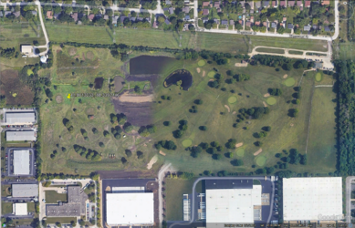
Default image, from July 2022
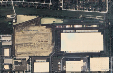
Dated July 2023


The left image, which is what is displayed by Google products by default, is from July of 2022, over a year previous to today, and depicts what appears to be a golf course in the area. However, it does appear to be to different images blended together in the middle of the course, making it more difficult to tell what the terrain there really looks like. Only when viewing the most recent available images in Google Earth, which are from July 2023, do the current buildings appear. Fortunately, while I was misled by the inaccurate imagery it wasn't dangerous to me in any way. I could simply not access the area. But had this been in particularly difficult terrain it wouldn't be difficult for a geohasher to believe they could adventure into an area that looks safe from the default imagery only to find the actual conditions encountered to be anything but.
Lesson learned, don't trust satellite imagery! Do diligent research before adventuring out.
Photos
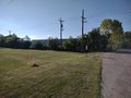
No access and visible construction site
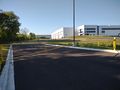
Not just gated, triple gated! (3rd gate out of frame)


Achievements
Tarasaurus earned the No trespassing consolation prize
|