Difference between revisions of "2023-09-04 49 10"
From Geohashing
Gefrierbrand (talk | contribs) (→Location) |
Gefrierbrand (talk | contribs) |
||
| Line 1: | Line 1: | ||
| − | + | {{meetup graticule | |
| − | |||
| − | |||
| − | |||
| − | |||
| − | |||
| − | |||
| − | |||
| − | |||
| lat=49 | | lat=49 | ||
| lon=10 | | lon=10 | ||
| date=2023-09-04 | | date=2023-09-04 | ||
| − | }} | + | }} |
== Location == | == Location == | ||
On a field near Wiesentheid | On a field near Wiesentheid | ||
== Participants == | == Participants == | ||
| − | + | *[[User:Santu|Santu]] | |
| − | + | *[[User:Gefrierbrand|Gefrierbrand]] | |
| + | *Pedro the dog | ||
| − | == | + | == Expedition == |
| − | + | Day three of our continued luck to be able to go on geohashing adventures without much effort. We were in the area anyway and only did a small detour to be able to visit Wiesentheid, which Gefrierbrand had hear of many times in his youth, but never actually visited. | |
| − | + | At first we had trouble getting good GPS reception (which is why the track starts strangely) but the aerial pictures were more than enough to walk in the right direction. After reaching the hash we then ventured to the nearby Schlosspark Schönborn and had a piece of cake while Pedro enjoyed dog-snacks. We then finished the obligatory walk around the lake before continuing on. | |
| − | |||
== Tracklog == | == Tracklog == | ||
| − | + | {{tracklog | T2023-09-04-15-51 gh.gpx}} | |
== Photos == | == Photos == | ||
| Line 33: | Line 25: | ||
--> | --> | ||
<gallery perrow="5"> | <gallery perrow="5"> | ||
| − | + | Image:2023-09-04_49_10_Gefrierbrand_1695059300657.jpg|very StupidGrin<sup>TM</sup> | |
Image:2023-09-04_49_10_Gefrierbrand_1693844139158.jpg|proof | Image:2023-09-04_49_10_Gefrierbrand_1693844139158.jpg|proof | ||
| − | + | Image:2023-09-04_49_10_Gefrierbrand_1695059346791.jpg|house in the Schlosspark | |
| − | |||
| − | |||
| − | Image:2023-09-04_49_10_Gefrierbrand_1695059346791.jpg|house | ||
</gallery> | </gallery> | ||
== Achievements == | == Achievements == | ||
{{#vardefine:ribbonwidth|100%}} | {{#vardefine:ribbonwidth|100%}} | ||
| − | + | {{land geohash | |
| + | | latitude = latitude (required) | ||
| + | | longitude = longitude (required) | ||
| + | | date = date (YYYY-MM-DD format) (required) | ||
| + | | name = name of achiever (optional) | ||
| + | | image = image name (optional) | ||
| + | }} | ||
__NOTOC__ | __NOTOC__ | ||
<!-- =============== USEFUL CATEGORIES FOLLOW ================ | <!-- =============== USEFUL CATEGORIES FOLLOW ================ | ||
Revision as of 18:09, 18 September 2023
| Mon 4 Sep 2023 in 49,10: 49.8013033, 10.3392146 geohashing.info google osm bing/os kml crox |
Location
On a field near Wiesentheid
Participants
- Santu
- Gefrierbrand
- Pedro the dog
Expedition
Day three of our continued luck to be able to go on geohashing adventures without much effort. We were in the area anyway and only did a small detour to be able to visit Wiesentheid, which Gefrierbrand had hear of many times in his youth, but never actually visited.
At first we had trouble getting good GPS reception (which is why the track starts strangely) but the aerial pictures were more than enough to walk in the right direction. After reaching the hash we then ventured to the nearby Schlosspark Schönborn and had a piece of cake while Pedro enjoyed dog-snacks. We then finished the obligatory walk around the lake before continuing on.
Tracklog
Photos
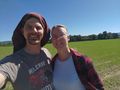
very StupidGrinTM
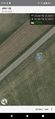
proof
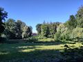
house in the Schlosspark


Achievements
| name of achiever (optional) earned the Land geohash achievement |