Difference between revisions of "2023-09-20 52 5"
FelixTheCat (talk | contribs) (Created page with "{{subst:Expedition |lat = 52 |lon = 5 |date = 2023-09-20 }}") |
FelixTheCat (talk | contribs) |
||
| Line 1: | Line 1: | ||
| − | + | {{meetup graticule | |
| − | |||
| − | |||
| − | |||
| − | |||
| − | |||
| − | |||
| − | |||
| − | |||
| lat=52 | | lat=52 | ||
| lon=5 | | lon=5 | ||
| date=2023-09-20 | | date=2023-09-20 | ||
| − | }} | + | }} |
== Location == | == Location == | ||
| − | + | In a forest near Putten, Gelderland province. | |
== Participants == | == Participants == | ||
| − | + | [[User:FelixTheCat|FelixTheCat]] ([[User talk:FelixTheCat|talk]]) | |
| − | |||
| − | |||
| − | |||
| − | |||
== Expedition == | == Expedition == | ||
| − | + | I drove towards Putten in the morning and parked the hashmobile in a small car park in the forest. I then walked towards the hash. When I got near, I found that the last path I was planning to take was blocked by a fallen tree. It looked like it was placed there deliberately, so I assumed this path was closed for some reason. No matter, there was another path a bit futher on. That one was similarly blocked, requiring a slightly longer detour. Finally, just when I thought I had found a direct path that would bring me to the point, I ran into a locked fence with a "no entry" sign. Disappointed yet again, I walked around a bit more and found the centre of gravity of the Netherlands. Then I went back to the hashmobile and did some more sightseeing in the wider area. | |
| − | |||
| − | |||
| − | |||
== Photos == | == Photos == | ||
| − | |||
| − | |||
| − | |||
<gallery perrow="5"> | <gallery perrow="5"> | ||
| + | Image:2023-09-20 52 5 FelixTheCat 1.JPG | Today's forest is called "Speulder- en Sprielderbos". | ||
| + | Image:2023-09-20 52 5 FelixTheCat 2.JPG | It's a nice forest. The weather is also rather pleasant. | ||
| + | Image:2023-09-20 52 5 FelixTheCat 3.JPG | I was planning to take this path, but it's kind of blocked. | ||
| + | Image:2023-09-20 52 5 FelixTheCat 4.JPG | This one then? Nope. | ||
| + | Image:2023-09-20 52 5 FelixTheCat 5.JPG | How about this? "Quiet area for wildlife. No entry" | ||
| + | Image:2023-09-20 52 5 FelixTheCat 6.png | We're 511 metres away at this point. | ||
| + | Image:2023-09-20 52 5 FelixTheCat 7.JPG | Lloyd and Lleroy are disappointed. | ||
| + | Image:2023-09-20 52 5 FelixTheCat 8.png | The closest we got was 148 metres. | ||
| + | Image:2023-09-20 52 5 FelixTheCat 9.JPG | About 2 km away is the centre of gravity of the Netherlands. Simply hook up your giant crane to this loop to lift up the entire country without spilling anyting. | ||
</gallery> | </gallery> | ||
== Achievements == | == Achievements == | ||
{{#vardefine:ribbonwidth|100%}} | {{#vardefine:ribbonwidth|100%}} | ||
| − | + | {{No trespassing | |
| + | | latitude = 52 | ||
| + | | longitude = 5 | ||
| + | | date = 2023-09-20 | ||
| + | | name = [[User:FelixTheCat|FelixTheCat]] ([[User talk:FelixTheCat|talk]]) | ||
| + | | distance = 148 m | ||
| + | }} | ||
__NOTOC__ | __NOTOC__ | ||
| − | |||
| − | |||
| − | |||
| − | |||
| − | |||
| − | |||
| − | |||
| − | |||
| − | |||
| − | |||
| − | |||
| − | |||
| − | |||
| − | |||
[[Category:Expeditions]] | [[Category:Expeditions]] | ||
| − | |||
[[Category:Expeditions with photos]] | [[Category:Expeditions with photos]] | ||
| − | |||
| − | |||
| − | |||
| − | |||
| − | |||
| − | |||
| − | |||
| − | |||
| − | |||
[[Category:Coordinates not reached]] | [[Category:Coordinates not reached]] | ||
| − | |||
| − | |||
| − | |||
| − | |||
| − | |||
[[Category:Not reached - No public access]] | [[Category:Not reached - No public access]] | ||
| − | |||
| − | |||
| − | |||
| − | |||
| − | |||
| − | |||
| − | |||
| − | |||
Revision as of 17:18, 20 September 2023
| Wed 20 Sep 2023 in 52,5: 52.2441685, 5.6656349 geohashing.info google osm bing/os kml crox |
Location
In a forest near Putten, Gelderland province.
Participants
Expedition
I drove towards Putten in the morning and parked the hashmobile in a small car park in the forest. I then walked towards the hash. When I got near, I found that the last path I was planning to take was blocked by a fallen tree. It looked like it was placed there deliberately, so I assumed this path was closed for some reason. No matter, there was another path a bit futher on. That one was similarly blocked, requiring a slightly longer detour. Finally, just when I thought I had found a direct path that would bring me to the point, I ran into a locked fence with a "no entry" sign. Disappointed yet again, I walked around a bit more and found the centre of gravity of the Netherlands. Then I went back to the hashmobile and did some more sightseeing in the wider area.
Photos
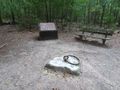
Today's forest is called "Speulder- en Sprielderbos".
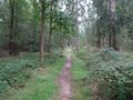
It's a nice forest. The weather is also rather pleasant.
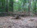
I was planning to take this path, but it's kind of blocked.
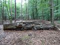
This one then? Nope.
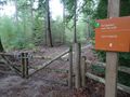
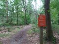
How about this? "Quiet area for wildlife. No entry"
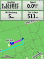
We're 511 metres away at this point.
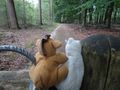
Lloyd and Lleroy are disappointed.
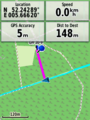
The closest we got was 148 metres.
About 2 km away is the centre of gravity of the Netherlands. Simply hook up your giant crane to this loop to lift up the entire country without spilling anyting.


Achievements
FelixTheCat (talk) earned the No trespassing consolation prize
|