2023-12-25 -37 145
| Mon 25 Dec 2023 in -37,145: -37.7567060, 145.0794080 geohashing.info google osm bing/os kml crox |
Location
Banksia Park
Participants
- Stevage
Plans
Lots of people planning to squeeze it around christmas plans.
Expedition 1
Expedition 2
I'd been hoping to get this on the way to/from christmas festivities. Departing from home, things looked good with a break in the rain. One minute from the turn off, the rain returns. I quickly decide to detour on my way home.
Approach after parking is pretty easy, I find Stevage's path in for a nice easy geohash (and a chance to explore a park I'd never been in before).
Expedition 3
Expedition 4
My original plan was to go early in the morning prior to the excess of eating and drinking that is Christmas. However, I was lured by people suggesting a late hash and (more importantly) sleeping in a lot.
This hash was reasonably close to where I live. This would have been more helpful if I was coming from home, but instead I went to my parents’ place for family Christmas, so it was rather further away. Given the intense rain when I was getting to Christmas, and threats of a “severe thunderstorm” from the weather bureau, I was considering just staying the night at my parents’. However, at 10pm, laden with Christmas presents and stuffed with food, I got on my bike and went into the rain.
The ride there went well, for the parts I knew, and terrifyingly, for the parts I didn’t know. There was at least one gravel-mud section that went OK although there was some dubious loss of traction from my svelte road bike tyres. I also made a questionable dash across Banksia St/Manningham Rd (on the way back I would discover this was unnecessary).
It was now extremely wet, and dark, and also there was occasional lightning.

I left my bike next to a tree and blundered in the general direction of the hash. I was confronted by a large tree/bush situation that admitted no obvious way in. I backed away and wandered a little bit to see if I could find another way, but this was unsuccessful as it was quite dark. I did however collect an array of bark and spiders on my body.
If you can’t go around it, you have to go through it, so with helmet firmly on I bashed my way through the brush and eventually found the hashpoint in a SpiderZone. Thankfully I was able to trick the GPS into thinking I was in the spiderbush, and I went to take a screenshot and... turned the phone off because it’s a new phone with a different button layout. Or alternatively, it was a sign that if you’re tricking the GPS you’re not hashing properly.
With the phone off it was now pleasantly dark, by which I mean, I could feel more spiders and could now hear an animal moving around in a terrifying way. The only option seemed to turn the phone back on and then squeeze in to the spider-lair, hold my phone out, and scream like a small child, which eventually produced an adequately close reading.
It was now raining even more. The good thing was that this washed the spiders off me a bit. The bad thing was I was now completely lost and had only a vague idea where my bike was.
I turned around and... saw the path that had been made by Expeditions 1, 2 and 3. Following this out was easy and had less tree climbing compared to my original route, and almost no spiders.

On my way out I tested out my brakes by almost crashing in to a wombat. The rain also closed the path I’d intended to use to get home requiring further detour.
Wildlife report: 3 × kangaroos, 1 × wombat, ∞ × spiders, 1 × terrifying noise creature (possibly wombat)
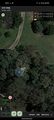
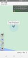
Tracklog
Photos
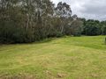
Outside the hash. Fortunately stevage had made a nice path in
Geohash success
Expedition Four success


Achievements