Difference between revisions of "2024-01-13 53 13"
From Geohashing
m (→Plans) |
(→Photos) |
||
| Line 35: | Line 35: | ||
--> | --> | ||
<gallery perrow="5"> | <gallery perrow="5"> | ||
| + | Image:IMG_20240113_viewfromviewpoint.jpg | Enjoying the scenic view, with shoe | ||
| + | Image:IMG_20240113_interestingfeature1.jpg | Looks promising! | ||
| + | Image:IMG_20240113_destinationreached.jpg | "You've reached your destination" | ||
| + | Image:IMG_20240113_viewfromhash.jpg | View from Hash | ||
</gallery> | </gallery> | ||
Revision as of 17:01, 13 January 2024
| Sat 13 Jan 2024 in 53,13: 53.4638022, 13.0150405 geohashing.info google osm bing/os kml crox |
Location
Participants
Plans
Plan is, (A) put on shoes and other relevant protections against the wintry environment, (B) walk roughly 6km, (C) reach geohash while daylight is still abounding. (~ 14:00 ?! Sorry, meetup-ers, I won't wait for official meetup-time!)
Expedition
Tracklog
Photos
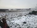
Enjoying the scenic view, with shoe
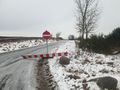
Looks promising!
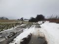
"You've reached your destination"
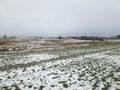
View from Hash


Achievements