Difference between revisions of "2024-02-06 32 35"
Yerushalmi (talk | contribs) (Created page with "{{subst:Expedition}}") |
Yerushalmi (talk | contribs) |
||
| Line 13: | Line 13: | ||
}}<!-- edit as necessary --> | }}<!-- edit as necessary --> | ||
== Location == | == Location == | ||
| − | + | Among farmland just south of Afula. The point is at the edge of a copse of trees that is probably public land, but it may be in the farmland surrounding the copse. | |
== Participants == | == Participants == | ||
| − | + | [[User:Yerushalmi|Yerushalmi]] ([[User talk:Yerushalmi|talk]]) | |
| − | |||
== Plans == | == Plans == | ||
| − | + | Train to Tel Aviv, train to wherever, then a bus to another bus to the nearby town of Givat Oz. The specifics of which train and which bus will depend on exactly when I leave, but I'll play it by ear. | |
== Expedition == | == Expedition == | ||
| − | + | This expedition was a failure from start to finish. | |
| + | |||
| + | First, I woke up very late because #4 kept waking up at night. | ||
| + | |||
| + | Second, I discovered upon reaching the train station and looking up what tickets I'd have to buy that the only routes offered to me by Moovit included a stopover in the town of Umm El-Fahm. I am Jewish. This might be a very bad idea. | ||
| + | |||
| + | So I had to improvise: I'd take a train to Ben Gurion Airport, another train to Biyamina, and a bus to another bus to a third bus that would take me to Givat Oz while bypassing Umm El-Fahm. | ||
| + | |||
| + | The trains were reliable as usual, but the first bus from Binyamina got stuck behind a Toyota that seemed to be deliberately driving down the one-lane road as slowly as possible. By the time we got freed up from that, we hit a traffic jam, and I missed the second bus I was planning on taking. The next one of that line wouldn't be for several hours yet... | ||
| + | |||
| + | Cue some frantic searching for alternatives. I eventually got off at (IIRC) Tzomet Karkur, intending on taking a different bus to Tzomet Megido (at the foot of Har Megiddo, a place known in English as Armageddon). From there it would be a 40-minute walk to the point. | ||
| + | |||
| + | Eh, I've walked longer distances before. I can do this. The worrying part is all the "private property, no trespassing" signs I'm seeing on the fields on the eastern side of the highway as I walked south. | ||
| + | |||
| + | Luckily, the path to the point 'didn't' have such a sign. Unluckily, it was incredibly muddy from recent rainfall. Massively muddy. Possibly the muddiest path I've ever been down, and that includes paths I've walked down 'during' massive rainfall. | ||
| + | |||
| + | Eventually I could see the copse of trees that I was looking for: | ||
| + | |||
| + | |||
| + | This probably isn't a good sign. The crops in the field around it are all fully grown (they looked to be some kind of leek or green onion), and there was literally no way through to the copse. I turned left to try to go around and see if there was a path inside, then turned right, then turned left again. No luck. I didn't get any closer than 300m to the point. | ||
| + | |||
| + | On the way back, I discovered via Moovit that there were no good buses back to the train network and I'd be getting home very late. And the only bus out of Givat Oz for quite some time arrived 20 minutes earlier than scheduled and drove right past the stop at speed when I wasn't ready to board. So I got a lift from an electrician, talked to him about my apartment's light bulb issues, and got off at a random intersection with a bus stop. | ||
| + | |||
| + | From there I could've taken a bus towards Afula or a bus towards Binyamina. Afula's train schedule is awful, so I decided to go towards Binyamina. This turned out to be a mistake; Route 65 was massively backed up and I lost a full hour. Trains are reliable, but buses... I ended up getting home at 8pm, having disappointingly burned the whole day. | ||
| − | |||
| − | |||
== Photos == | == Photos == | ||
<!-- Insert pictures between the gallery tags using the following format: | <!-- Insert pictures between the gallery tags using the following format: | ||
Image:2020-##-## ## ## Alpha.jpg | Witty Comment | Image:2020-##-## ## ## Alpha.jpg | Witty Comment | ||
| − | --> | + | --><gallery> |
| − | <gallery | + | File:20240206_133642.jpg | The Armageddon Bus Stop |
| + | File:20240206_141657.jpg | You want to know about mud? I know about mud. | ||
| + | File:20240206_142037.jpg | Some kind of animal tracks in the mud | ||
| + | File:20240206_142140.jpg | Crops blocking my way | ||
| + | File:20240206_142333.jpg | No way through here | ||
| + | File:20240206_143749.jpg | No way through here | ||
| + | File:20240206_145923.jpg | No way through here | ||
| + | File:20240206_151852.jpg | A tangerine orchard I saw on the way back | ||
</gallery> | </gallery> | ||
| − | |||
| − | |||
| − | |||
| − | |||
| − | |||
| − | |||
| − | |||
| − | |||
| − | |||
| − | |||
| − | |||
| − | |||
| − | |||
| − | |||
| − | |||
| − | |||
| − | |||
| − | |||
[[Category:Expeditions]] | [[Category:Expeditions]] | ||
| − | |||
[[Category:Expeditions with photos]] | [[Category:Expeditions with photos]] | ||
| − | |||
| − | |||
| − | |||
| − | |||
| − | |||
| − | |||
| − | |||
| − | |||
| − | |||
[[Category:Coordinates not reached]] | [[Category:Coordinates not reached]] | ||
| − | |||
| − | |||
| − | |||
| − | |||
| − | |||
[[Category:Not reached - No public access]] | [[Category:Not reached - No public access]] | ||
| − | |||
| − | |||
| − | |||
| − | |||
| − | |||
| − | |||
| − | |||
| − | |||
Revision as of 12:29, 7 February 2024
| Tue 6 Feb 2024 in 32,35: 32.5542443, 35.2100551 geohashing.info google osm bing/os kml crox |
Contents
Location
Among farmland just south of Afula. The point is at the edge of a copse of trees that is probably public land, but it may be in the farmland surrounding the copse.
Participants
Plans
Train to Tel Aviv, train to wherever, then a bus to another bus to the nearby town of Givat Oz. The specifics of which train and which bus will depend on exactly when I leave, but I'll play it by ear.
Expedition
This expedition was a failure from start to finish.
First, I woke up very late because #4 kept waking up at night.
Second, I discovered upon reaching the train station and looking up what tickets I'd have to buy that the only routes offered to me by Moovit included a stopover in the town of Umm El-Fahm. I am Jewish. This might be a very bad idea.
So I had to improvise: I'd take a train to Ben Gurion Airport, another train to Biyamina, and a bus to another bus to a third bus that would take me to Givat Oz while bypassing Umm El-Fahm.
The trains were reliable as usual, but the first bus from Binyamina got stuck behind a Toyota that seemed to be deliberately driving down the one-lane road as slowly as possible. By the time we got freed up from that, we hit a traffic jam, and I missed the second bus I was planning on taking. The next one of that line wouldn't be for several hours yet...
Cue some frantic searching for alternatives. I eventually got off at (IIRC) Tzomet Karkur, intending on taking a different bus to Tzomet Megido (at the foot of Har Megiddo, a place known in English as Armageddon). From there it would be a 40-minute walk to the point.
Eh, I've walked longer distances before. I can do this. The worrying part is all the "private property, no trespassing" signs I'm seeing on the fields on the eastern side of the highway as I walked south.
Luckily, the path to the point 'didn't' have such a sign. Unluckily, it was incredibly muddy from recent rainfall. Massively muddy. Possibly the muddiest path I've ever been down, and that includes paths I've walked down 'during' massive rainfall.
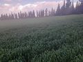
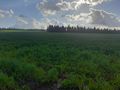
Eventually I could see the copse of trees that I was looking for:
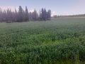
This probably isn't a good sign. The crops in the field around it are all fully grown (they looked to be some kind of leek or green onion), and there was literally no way through to the copse. I turned left to try to go around and see if there was a path inside, then turned right, then turned left again. No luck. I didn't get any closer than 300m to the point.
On the way back, I discovered via Moovit that there were no good buses back to the train network and I'd be getting home very late. And the only bus out of Givat Oz for quite some time arrived 20 minutes earlier than scheduled and drove right past the stop at speed when I wasn't ready to board. So I got a lift from an electrician, talked to him about my apartment's light bulb issues, and got off at a random intersection with a bus stop.
From there I could've taken a bus towards Afula or a bus towards Binyamina. Afula's train schedule is awful, so I decided to go towards Binyamina. This turned out to be a mistake; Route 65 was massively backed up and I lost a full hour. Trains are reliable, but buses... I ended up getting home at 8pm, having disappointingly burned the whole day.
Photos
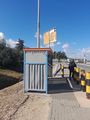
The Armageddon Bus Stop
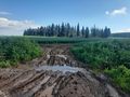
You want to know about mud? I know about mud.
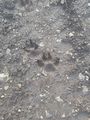
Some kind of animal tracks in the mud

Crops blocking my way
No way through here
No way through here
No way through here
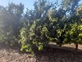
A tangerine orchard I saw on the way back


