Difference between revisions of "2024-04-14 -37 145"
(→Photos) |
(→Photos) |
||
| Line 35: | Line 35: | ||
File:2024-04-14 -37 145 one of those dead trees.jpg|...one of those dead trees. | File:2024-04-14 -37 145 one of those dead trees.jpg|...one of those dead trees. | ||
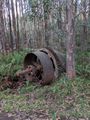
File:2024-04-14 -37 145 outdoor sculpture.jpg|A highlight along the road. | File:2024-04-14 -37 145 outdoor sculpture.jpg|A highlight along the road. | ||
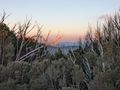
| − | + | File:2024-04-14 -37 145 another nice sunset.jpg|It's beautiful up here. | |
</gallery> | </gallery> | ||
Revision as of 11:29, 14 April 2024
| Sun 14 Apr 2024 in -37,145: -37.4838776, 145.8611153 geohashing.info google osm bing/os kml crox |
Location
75 m from Upper Taggerty Rd, Lake Mountain
Participants
Plans
Expedition
Well, that was somewhat ill-judged. This area burned a few years ago, so it is quite atmospheric and interesting to see the regrowth. Thus I justified the drive up to Lake Mountain on the basis of exploring a new area on my bike once I got there. Turns out that the loop on the map doesn't exist anymore, so it ended up being an out and back along a really rough, rocky, grassy track with odd muddy bits and fallen trees across the road. 75 m off the road turned out to be a big deal in the dense regrowth, groveling up the mountain side along slippery fallen trees. Getting back down was easier, using the cowboy slide technique - I'll leave that to your imagination. At least there were no leeches! Luckily there was some excellent old abandoned steampunk machinery to inspect on the way back and a fine sunset.
Tracklog
Photos

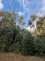
Lots of green.

A dead tree marks the spot...
...one of those dead trees.
A highlight along the road.
It's beautiful up here.


Achievements