Difference between revisions of "2024-04-21 65 25"
From Geohashing
| (3 intermediate revisions by the same user not shown) | |||
| Line 3: | Line 3: | ||
| lon={{#explode:{{SUBPAGENAME}}| |2}} | | lon={{#explode:{{SUBPAGENAME}}| |2}} | ||
| date={{#explode:{{SUBPAGENAME}}| |0}} | | date={{#explode:{{SUBPAGENAME}}| |0}} | ||
| − | }} | + | }} |
== Location == | == Location == | ||
| − | The point on a topographic map: [https://kripakko.neocities.org/geohash_maplink?{{# | + | In a forest near Iso Lavalampi pond, Haukipudas, Oulu. |
| + | |||
| + | The point on a topographic map: [https://kripakko.neocities.org/geohash_maplink?{{#replace:{{SUBPAGENAME}}| |_}}k] | ||
== Participants == | == Participants == | ||
| Line 11: | Line 13: | ||
== Expedition == | == Expedition == | ||
| − | + | Success! I drove to the hashpoint, and this time I attempted filming the expedition using an action camera that I set up as a dashcam. It did not turn out too great, but I may still edit and publish it when I have time. | |
== Tracklog == | == Tracklog == | ||
| − | + | {{tracklog|2024-04-21 65 25 tracklog.gpx}} | |
== Photos == | == Photos == | ||
| − | < | + | <gallery perrow="1"> |
| − | Image: | + | Image:2024-04-21 65 25 qdgn.png|Proof of location and time, screenshot of [https://kripakko.neocities.org/qdgn QDGN]. |
| − | |||
| − | |||
</gallery> | </gallery> | ||
== Achievements == | == Achievements == | ||
{{#vardefine:ribbonwidth|100%}} | {{#vardefine:ribbonwidth|100%}} | ||
| − | + | ||
| + | {{Land geohash | ||
| + | | name=[[User:Kripakko|Kripakko]] | ||
| + | | latitude={{#explode:{{SUBPAGENAME}}| |1}} | ||
| + | | longitude={{#explode:{{SUBPAGENAME}}| |2}} | ||
| + | | date={{#explode:{{SUBPAGENAME}}| |0}} | ||
| + | }} | ||
| + | {{Frozen geohash | ||
| + | | name=[[User:Kripakko|Kripakko]] | ||
| + | | latitude={{#explode:{{SUBPAGENAME}}| |1}} | ||
| + | | longitude={{#explode:{{SUBPAGENAME}}| |2}} | ||
| + | | date={{#explode:{{SUBPAGENAME}}| |0}} | ||
| + | | temperature=−2 °C | ||
| + | }} | ||
__NOTOC__ | __NOTOC__ | ||
| − | + | ||
| − | |||
[[Category:New report]] | [[Category:New report]] | ||
| − | <!-- | + | <!-- |
| − | |||
| − | |||
| − | |||
| − | |||
| − | |||
| − | |||
| − | |||
| − | |||
| − | |||
[[Category:Expeditions]] | [[Category:Expeditions]] | ||
| − | |||
[[Category:Expeditions with photos]] | [[Category:Expeditions with photos]] | ||
[[Category:Expeditions with videos]] | [[Category:Expeditions with videos]] | ||
| − | [[Category: | + | [[Category:Coordinates reached]] |
--> | --> | ||
| − | |||
| − | |||
| − | |||
| − | |||
| − | |||
| − | |||
| − | |||
| − | |||
| − | |||
| − | |||
| − | |||
| − | |||
| − | |||
| − | |||
| − | |||
| − | |||
| − | |||
| − | |||
| − | |||
| − | |||
| − | |||
Latest revision as of 19:13, 21 April 2024
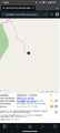
| Sun 21 Apr 2024 in 65,25: 65.2448582, 25.7472927 geohashing.info google osm bing/os kml crox |
Location
In a forest near Iso Lavalampi pond, Haukipudas, Oulu.
The point on a topographic map: [1]
Participants
Expedition
Success! I drove to the hashpoint, and this time I attempted filming the expedition using an action camera that I set up as a dashcam. It did not turn out too great, but I may still edit and publish it when I have time.
Tracklog
Photos
Proof of location and time, screenshot of QDGN.

Achievements
Kripakko earned the Land geohash achievement
|

Kripakko earned the Frozen Geohash Achievement
by reaching the (65, 25) geohash on 2024-04-21 while the temperature was −2 °C.