Difference between revisions of "2024-05-04 62 26"
From Geohashing
| Line 17: | Line 17: | ||
== Photos == | == Photos == | ||
<gallery perrow="12"> | <gallery perrow="12"> | ||
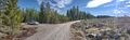
| + | Image:2024-05-04_62_26_01-softroad.jpg | The soft field road through which I did not dare to drive. | ||
| + | Image:2024-05-04_62_26_02-swans.jpg | A pair of whooper swans (''Cygnus cygnus''). | ||
| + | Image:2024-05-04_62_26_03-coltsfeet.jpg | Blossoming coltsfeet (''Tussilago farfara''). | ||
| + | Image:2024-05-04_62_26_04-junction.jpg | The car temporarily parked near a road junction. | ||
| + | Image:2024-05-04_62_26_05-parked.jpg | The car parked where I continued on foot, about 240 metres to go. | ||
| + | Image:2024-05-04_62_26_06-usnea.jpg | Lots of beard lichen (''Usnea'' sp.) growing on the spruces. | ||
| + | Image:2024-05-04_62_26_07-lingonberry.jpg | A lingonberry that had survived the winter. | ||
| + | Image:2024-05-04_62_26_08-selfie.jpg | Hashpoint reached, Stupid Grin™ | ||
| + | Image:2024-05-04_62_26_09-qdgn.png | Proof of location and time, screenshot of [https://kripakko.neocities.org/qdgn QDGN]. | ||
| + | Image:2024-05-04_62_26_10-lichen.jpg | Lichens, mosses and subshrubs growing on some rocks. | ||
| + | Image:2024-05-04_62_26_11-manure.jpg | Moose manure. | ||
| + | Image:2024-05-04_62_26_12-lake.jpg | View to lake Kutemainen. | ||
</gallery> | </gallery> | ||
Revision as of 16:36, 5 May 2024
| Sat 4 May 2024 in 62,26: 62.8657128, 26.4690160 geohashing.info google osm bing/os kml crox |
Location
In a forest near Sonkari, Vesanto.
The point on a topographic map: [1]
Participants
Expedition
Photos
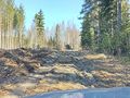
The soft field road through which I did not dare to drive.
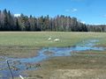
A pair of whooper swans (Cygnus cygnus).
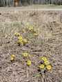
Blossoming coltsfeet (Tussilago farfara).
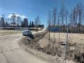
The car temporarily parked near a road junction.
The car parked where I continued on foot, about 240 metres to go.
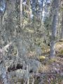
Lots of beard lichen (Usnea sp.) growing on the spruces.
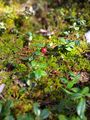
A lingonberry that had survived the winter.
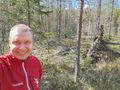
Hashpoint reached, Stupid Grin™
Proof of location and time, screenshot of QDGN.
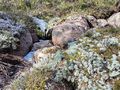
Lichens, mosses and subshrubs growing on some rocks.
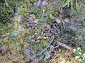
Moose manure.
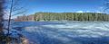
View to lake Kutemainen.


Achievements
Kripakko earned the Land geohash achievement
|