Difference between revisions of "2024-05-09 47 -122"
From Geohashing
Coyotebush (talk | contribs) ([live picture]Panorama from the road) |
Coyotebush (talk | contribs) ([live picture]Google Maps thinks you can teleport through this to a bus stop [https://openstreetmap.org/?mlat=47.50261944&mlon=-122.38211944&zoom=16 @47.5026,-122.3821]) |
||
| Line 55: | Line 55: | ||
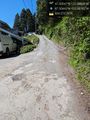
Image:2024-05-09_47_-122_coyotebush_1715302219636.jpg|Panorama from the road | Image:2024-05-09_47_-122_coyotebush_1715302219636.jpg|Panorama from the road | ||
| + | |||
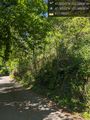
| + | Image:2024-05-09_47_-122_coyotebush_1715302448754.jpg|Google Maps thinks you can teleport through this to a bus stop [https://openstreetmap.org/?mlat=47.50261944&mlon=-122.38211944&zoom=16 @47.5026,-122.3821] | ||
</gallery> | </gallery> | ||
Revision as of 00:54, 10 May 2024
| Thu 9 May 2024 in 47,-122: 47.5054684, -122.3886777 geohashing.info google osm bing/os kml crox |
Location
Participants
Plans
Expedition
- On board an H Line bus, fastest among 3 simultaneous departures to Westwood Village, to connect with infrequent route 22. -- Coyotebush (talk) @47.6047,-122.3333 13:41, 9 May 2024 (PDT)
Tracklog
Photos
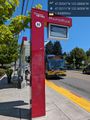
Route 22 @47.5211,-122.3651

Goodbye bus @47.5065,-122.3816
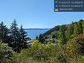
Roadside overlook @47.5038,-122.3823
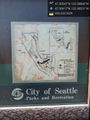
Park map not actually at "you are here" @47.5042,-122.3853
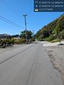
Heading north @47.5030,-122.3859
End of pavement @47.5044,-122.3878
Hillside @47.5056,-122.3889

Grin up the hill @47.5056,-122.3888
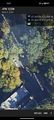
Best GPS screenshot

Panorama from the road
Google Maps thinks you can teleport through this to a bus stop @47.5026,-122.3821


Achievements