Difference between revisions of "File:Globalhash-at-a-glance-example.png"
From Geohashing
imported>Danatar (Example: Globalhashpoint for 2008-09-10, the W30-adjusted coordinate offset for 2008-09-10 was .2642955149758937 and .45661491254372155. Red line for latitude offset (.26) and yellow line for longitude offset (.45), the globalhash is in the south Atlantic) |
imported>Danatar m |
||
| Line 2: | Line 2: | ||
[[Category:Globalhash]] | [[Category:Globalhash]] | ||
[[Category:Globalhash achievement]] | [[Category:Globalhash achievement]] | ||
| + | [[Category:Danatar]] | ||
Revision as of 23:51, 8 November 2008
Example: Globalhashpoint for 2008-09-10, the W30-adjusted coordinate offset for 2008-09-10 was .2642955149758937 and .45661491254372155. Red line for latitude offset (.26) and yellow line for longitude offset (.45), the globalhash is in the south Atlantic Ocean.
File history
Click on a date/time to view the file as it appeared at that time.
| Date/Time | Thumbnail | Dimensions | User | Comment | |
|---|---|---|---|---|---|
| current | 16:21, 30 January 2020 | 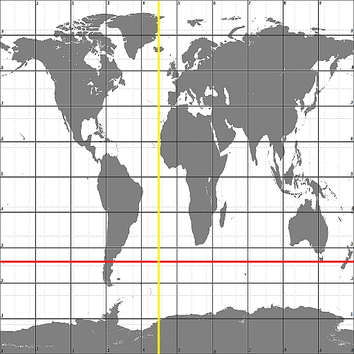 | 512 × 512 (72 KB) | Maintenance script (talk | contribs) |
- You cannot overwrite this file.
File usage
There are no pages that link to this file.