Difference between revisions of "Template:Expedition Images2/2017-07-24"
imported>1PE (→Expedition) |
imported>1PE (→Photos) |
||
| Line 42: | Line 42: | ||
--> | --> | ||
<gallery perrow="5"> | <gallery perrow="5"> | ||
| + | Image:2017-07-24_-35_149-house.jpg|The hash is along the side of this house. | ||
| + | Image:2017-07-24_-35_149_down.jpg|Down the reserve | ||
| + | Image:2017-07-24_-35_149_up.jpg|Up the reserve | ||
| + | Image:2017-07-24_-35_149_over.jpg|Over from the reserve, the hill. | ||
</gallery> | </gallery> | ||
Revision as of 14:05, 24 July 2017
| Mon 24 Jul 2017 in -35,149: -35.1800632, 149.1127790 geohashing.info google osm bing/os kml crox |
Location
The hash is 'inside' a house in a northern suburb of Canberra, the national Capital of Australia. It is about 2m from each of the side and back (southern) wall. The suburb is named Ngunnawal, which is the Australian Aboriginal name for the local tribe; pronounced in English as "Nunn-a wol"; said in the local language as something line "N-gkunn-ar-wol".
Participants
Plans
1PE
Drive by on my way home from work.
Expedition
1PE
I took a long way home, but not a lot out of my way. There was a parking bay on the single-lane road, and I then walked about 100m to opposite the house where the hash is 'inside' the back. I took several pictures, while seeming to appear not 'odd' to several groups of people walking their dogs along the path over from the house. I also took pictures of the trees on the reserve, where someone from the local government had lopped the trees and left the branches for later collection.
Tracklog
Photos
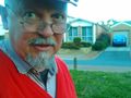
The hash is along the side of this house.
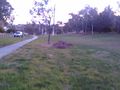
Down the reserve
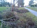
Up the reserve
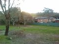
Over from the reserve, the hill.


Achievements