Difference between revisions of "User:Mirca"
imported>Mirca (→Expedition) |
imported>Mirca (→Location) |
||
| Line 17: | Line 17: | ||
<!-- edit as necessary --> | <!-- edit as necessary --> | ||
__NOTOC__ | __NOTOC__ | ||
| − | |||
| − | |||
| − | |||
| − | |||
== Participants == | == Participants == | ||
<!-- who attended: If you link to your wiki user name in this section, your expedition will be picked up by the various statistics generated for geohashing. You may use three tildes ~ as a shortcut to automatically insert the user signature of the account you are editing with. | <!-- who attended: If you link to your wiki user name in this section, your expedition will be picked up by the various statistics generated for geohashing. You may use three tildes ~ as a shortcut to automatically insert the user signature of the account you are editing with. | ||
Revision as of 19:56, 17 June 2014
| Sun 8 Jun 2014 in 62,27: 62.8509933, 27.4917226 geohashing.info google osm bing/os kml crox |
Participants
Mirca and her son.
Plans
It was sunny Sunday evening. We were driving home from my relatives, and decided to visit the meetup point which was near our route
Expedition
We were driving from Karttula toward the city of Kuopio. We turned to the road 5550 leading into the village of Haminalahti. We passed the village and turned left to the sand road named Jalkalantie. The road went through the forest and also passed some nice farmhouses. After about 2 km road was paved with very rough gravel. Fortunately we were quite near to the point. We left the car and walked 30 m from the road through the very thick spruce forest. The meetup point was there on a little nice clearing. We liked it was very easy to get to that hashpoint. It was not so easy to start driving home. The car was on the bumpy ground of the roadside, and it needed some hard pushing before we got it to the road.
Photos
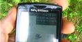
Success!

The meeting point in the middle of the clearing
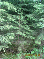
Spruces grow very thickly
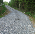
The road with some gravel


Achievements