2008-05-21 54 -2
From Geohashing
Note: This expedition used an old version of the Geohashing algorithm before the 30W Time Zone Rule was enacted.
| Wed 21 May 2008 in 54,-2: 54.1794680, -2.8615360 geohashing.info google osm bing/os kml crox |
About
On 21st May 2008, the day the algorithm was published, the geohash for Carlisle using the original algorithm was a spot on the coast near Silverdale at 54.179467°, -2.861537°.
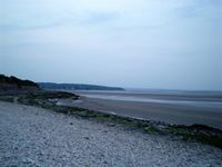
While Google maps shows this as being on land, it is actually in the treacherous sands of Morecambe Bay. The closest accessible location was a beach near small caravan park, visible on the aerial view.
People
Nick Taylor, around 9pm.
Photos
The coordinates are in the bay.
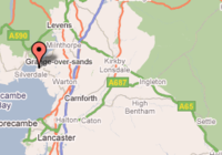
Coordinates as generated by the original algorithm.

