2008-06-03 53 9
| Tue 3 Jun 2008 in 53,9: 53.7427834, 9.6356494 geohashing.info google osm bing/os kml crox |
About
The coordinates of this geohash are
53.7427834473658905, 9.6356494013762755
The hash was near "Elmshorn" on a field on private property.
Expedition
Hermann and Felix were there:
It was a hot, muggy day and the weather forecast claimed, it was going to stay that way the whole day. We put sunblocker on since we dont like to get a sunburn. We got on our bikes at 14:15. I asked my navigation device to guide us to the geohash. We found out that, if in bicycle-mode, the route is not the shortest possible, but avoides big open roads and uses roads further off. Additionally it follows the bee-line until an obstacle (in this case, a river) is in the way. It guided us there and then looked for a path to the next bridge. Hell, why do I even have a GPS?
Bicycling through the countryside we noticed a thunderstorm approaching from the south. We instantly knew that it was possibly going to rain, but that wouldn't stop us. We got soaked 5km before we reached destination. It was a really big thunderstorm (in german measurements... american ones are still bigger in the same way that america is bigger than germany). We kept going and rode our bikes right into the storm. The thunderbolts scared the hell out of us. Take a look at the gallery: Those are far away. The lightning struck the house at 53°44'10.46"N, 9°37'55.38"E - way too close, if you ask me.
We reached the road near the field at about 16:00 (30 km). Originally we planned to jump over the fence and walk over to the spot, but we were really afraid to be thunderstruck (Felix is over 6,5 ft tall - being the highest point on an open field seemed to be a bad idea). So we decided to stay at the road and point at the spot. Not having a proper analog paper map, I made a sign error so we are pointing in exactly the opposite direction. In the correct direction, a sign told us that we were not allowed to enter this private property.
After bicycling through the rain a couple of minutes we decided it was better to use public transport for the way back. We stopped at a supermarket, bought bread, a pack of Kinder Riegel (yaaay) and a couple of sausages. We ate everything on the train. As we changed trains, an inspector tried to charge us 15,- € because bikes in trains were not allowed at that time of day. We didn't give him anythin, he did not do something either, so we just got on the train and left.
Things we learned on this expedition:
- Do not trust the weather forecast
- Bring proper map
- Be prepared
Technical details (trip from home to hash):
- Trip: 33.1 km
- Time: 1:55 h
- mean speed: 17.27 km/h
- peak speed: 40.67 km/h
- Pictures

Hermann pointing in the wrong direction.

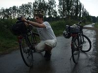
Felix not pointing at the geohash.
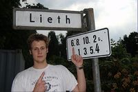
This sign says "leet" and... wait... are those coordinates?
Felix tries to catch a lightning using his bike in place of a tripod.
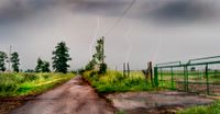
The thunderbolts scared the hell out of us.
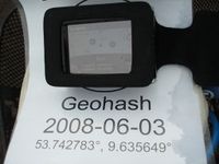
Hermann's mobile navigation device showing the coordinates when we were nearest to the geohash. Note that it's a cheap gps: The last 3 digits update randomly.


