2008-06-09 -41 175
| Mon 9 Jun 2008 in Upper Hutt, New Zealand: -41.1621517, 175.0417802 geohashing.info google osm bing/os kml crox |
Contents
[hide]The Location
The site is in the hills behind Trentham. It overlooks Heretaunga, Silverstream, and Trentham. Although one map I had (Wises) shows it to be in a scenic reserve, the hash is actually on Department of Corrections land as it is fairly near the prison.
The Geohash
I (nzsteak) set off at about 10.30 from Wellington to Upper Hutt to get to the hash hopefully around lunch time. Plan A was to drive down a road shown on the map which would get to within 1km of the hash. I'd played golf at the nearby golf course previously, but had forgotten that this area contained a number of firing ranges. The road I wanted went right up the middle of one of them and I wasn't ballsy enough to go up.
Plan B - I drove further along the road to try and find a place that wasn't a firing range. This was taking me further from the hash, but I figured that once I got up into the hills I could double back and walk along the ridgeline fairly easily. The fence had a number of "Defense Area" signs so I didn't want to cross over there.
Much farther along the road I came to a different fence that didn't have any signs on it so I parked the car and headed up through the trees and scrub to get to the top of the ridge. I managed to hack my way through the bush and then turned and headed for the hash.
I hadn't managed to source a handheld GPS beforehand so I was relying on compass skills. I'd worked out the angles to a couple of places in the town below beforehand, and as I was pretty high up I thought there wouldn't be any problems getting a location. However, the bush turned out to be very dense so I climbed a couple of trees on the way to see where I was.
I found the Geohash from the top of another tree. Yay! Time for some sandwiches and chocolate and drink. Took some photos and the headed off. I had seen another road on the map and thought it'd be easier to head for that one and then walk along the flat at the bottom of the hills so I went down the bank to meet up with it.
Turns out that the road was actually part of a prison (though it was outside the razor wire). I walked around the wire for a bit and then a number of friendly officers drove up in a van and asked for ID. I considered trying to explain the geohash concept, but in the end went with the "tramping in the hills" story. The officers drove me out of the prison complex and dropped me off on the road, where I walked to where the car was and headed home.
Just for the future, if the hash happens to fall anywhere on that range (between Blue Mountains, Trentham, Mansfield, Wallaceville) I wouldn't recommend trying to get to it! The officers were very nice to me but probably wouldn't take to kindly to many more encounters with geohashers!
Pictures

First plan scrapped - there weren't any red flags flying, but I didn't want to risk it anyway.
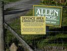
And again with the inaccessible land
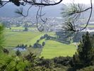
This is the view from halfway to the hash over Upper Hutt, you can see a bit of the golf course on the right where I was taking a bearing from

I climbed this tree to see where I was after hacking through very dense bush at the top of the ridge
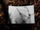
Made a sign for the geohash, put it at my best guess after climbing another tree


Achievements
nzsteak earned the Graticule Unlocked Achievement
|