2008-06-28 47 -120
From Geohashing
| Sat 28 Jun 2008 in Wenatchee: 47.6581110, -120.3656342 geohashing.info google osm bing/os kml crox |
47.65811°, -120.365635° is located just below Dinkelman Ridge (near Entiat), about 200 feet off a forest service road.
3000 foot elevation gain in about 5 miles. No walk in the park.

Who showed up?
- PBnJ (Aaron & Jeska)
- Skylar
- Orville
- Suzie Q (the car)
Activities/Adventures
- Poi.
- Stick-ball.
- Chalk drawings.
Also...
- Aaron saw two deer.
- Skylar found rose quartz and wild dill.
- Orville got cell phone reception.
- Jeska navigated.
Afterwards, we went out for mongolian barbecue and old fashioned ice cream sodas.
Achievements
- Drag-Along Geohash: PBnJ enlisted Skylar and Orville, who had never heard of geohashing before but were game for a random adventure.
- No Batteries Geohash: Our GPS supplier fell through at the last minute, so we had to rely on GoogleMap's Terrain View and the car's trip-ometer. Would have gone the last 200 feet (off-road) with measuring string and a compass, but the straightest route was also straight up, and heavily vegetated, so we went around, and eyeballed it with just the compass.
- Circus Geohash: Orville, poi master! (Aaron also made an attempt.) We would have also tried slacklining if there had been more sturdy trees available.
- MNIMB Geohash: This goes to the car, for getting us within 200 feet of the location. The last 5 or so miles were along a very steep, narrow, dusty, and primitive forest service road. Orville got out and moved rocks every once in a while. Suzie gained a few paint scratches, and we don't want to think about the dents she probably has on the undercarriage! We're just glad we found a place to turn around.
Pictures
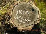
Fun with chalk!
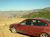
Suzie, the amazing car that made it up the hill.
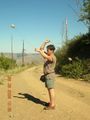
Orville's mad poi skills.
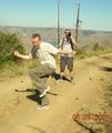
Aaron attempting the poi while Skylar looks on.
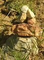
Quartz cairn.
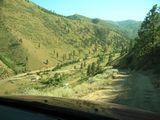
Steeper than it looks.


(Ignore the time-imprint... I thought I corrected that. I promise, we got there at about 4 pm!)
Return to: Wenatchee, Washington