2008-08-09 52 6
| Sat 9 Aug 2008 in 52,6: 52.0913829, 6.0585948 geohashing.info google osm bing/os kml crox |
People
havik and Arvid
Achievements
Expedition
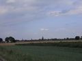
Arvid's tracklog by bicycle.
From Enschede, the closest hash was in 52 7, only 20-25kms away. For Arvid that's not really a challenge by bicycle. It would be a challenge for havik, but Arvid couldn't convince her to cycle there. Also, the hash was again in some farmfield.
Arvid also noticed most recent hashes reported were in Germany, and 52 7 would be Germany again. BUT! The hash in 52 6 (his own graticule) looked like it was in the woods, and about 70km away. 140km cycling is challenging, and the hash itself would be a bit more interesting than yet another farmfield too. havik agreed on the spot, and mentioned picnic in the woods would be nice.
Arvid left home around 12:30, keeping in mind that there would be headwind all way, and he was taking a ferry. That is a bit longer, but he avoided the saturday afternoon-rush in the center of Zutphen this way. He had the rush in Vorden instead, but Vorden is quite a bit smaller, and so is the rush. The ferry wasn't a long wait, it only kept Arvid up for about 6 minutes or so(GPS data logging rules!). Arvid did take a picture of the sign next to it with a gmail-address, but forgot to photograph the ferry or the view from there.
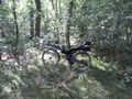
At 15:40 Arvid arrived at the point where he stopped fancying cycling, after 150m offroading. He noticed it was early and started walking. After about 200m he really should go off the path. But since this walking cost a lot of time, he decided to walk&cycle back, and wait for more people to show up at the nearest main road. He parked his bike in a very distinctive matter in the middle of the road, so other people would notice. In the meantime Arvid had 2 bananas. The second one peeled nicely in 4 parts, so it would make a nice X making a XKCD-mark at the spot. He put the peel back in his bag.
At 16:00 havik showed up, taking the road that was only for people that live there and cyclists/walkers. She completely missed the bike that stood in the middle of the road. She returned since she did notice she shouldn't drive on that small road, and parked her car at the restaurant 100m northwest of the crossing from where the real hashing started. Together havik and Arvid walked to the place Arvid was before. A total walk of about 500m.
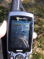
And then it was time to leave the path. The hash was probably about 40m off that path, but since it was in the middle of the woods, there was a bit of a problem to get a proper GPS signal. Even standing still it would still think they were moving. They have been to the spot, but weren't able to make a picture of the GPS showing the coordinates. The tracklog is proof instead. There was also the problem that havik's print didnt show the coordinates, and Arvid left everything except GPS-device and camera on his bike, at the place where they went off the path. So first they photographed the coordinates programmed into the device as the hashpoint, and then they tried to let the GPS display these coordinates. Which was chanceless.
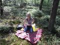
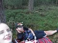
havik looked for a nice spot nearby to lay down her tablecloth for a picnic. From the average the GPS showed that was about 6m next to the spot, which is in the range of the deviation, at least in the woods. havik also brought cake, and forks and dishes, so it was really a proper picnic. Thanks for that! (Arvid always forgets to thank for these sorts of things)
After the cake Arvid and havik laid down on the cloth and had a chat while looking at the sky, where airplanes went their ways, and clouds blew by. Around 17:10 they went back to the parking spot, and talked about maps. Arvid found the banana peel in his bag. Remembering he -again- didnt mark the hash in a XKCD-manner. At 17:30 Arvid started his ride home, being optimistic since there was backwind! That was misplaced, but the way back wasn't as bad as the Münster trip. Arvid arrived home a bit after 20:30, where he'd hoped for 20:00. The way back had no ferry, and was around 3km shorter because of the different route. After 17:00 the saturday-shopping-rush is usually gone, and that was the case in Zutphen, as expected.
The #3 waypoint was accidentally made while stopping for a pee. And there is an odd straight line 2-3km later, when the batteries of the GPS died. Arvid stopped and replaced them when he noticed. (He ignored it when the GPS was beeping and claiming it was out of battery earlier).
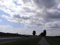
Thinking of Holland...
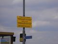
The ferry has an e-mail address!
Bicycle parked on a discrete spot
As close as one could reasonably get with any vehicle
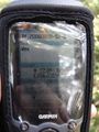
The coordinates for the spot

The tracklog of getting to the exact spot
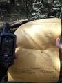
A complete useless picture, showing haviks print with no coordinates.
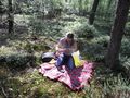
havik opening the box of pie for the picnic
havik being distracted with that by some guy with a camera
Proof of time and date
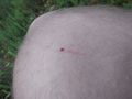
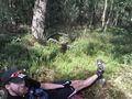
Raptors had gotten a hold of Arvid's knee
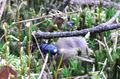
Other wild animals
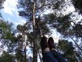
havik trying to make a picture of Arvid
Proof of Arvid having feet
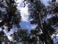
View to the sky from what we claimed as the hashpoint
Nice socks
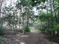
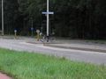
The path closest to the hashpoint
Picture of the way back, near Zutphen


