2008-08-14 -33 151
| Thu 14 Aug 2008 in -33,151: -33.5793654, 151.1369415 geohashing.info google osm bing/os kml crox |
Location
On the shore of Half Moon Bay, Berowra Waters.
Attendees
All attendees earned the No trespassing consolation prize
|
All attendees earned the Done with Nature consolation prize
|
All attendees earned the Twister Geohash Achievement
|
Report
| “ | It's still a fair way
|
” |
—Shady (on consulting his iPhone)
| ||
Shady, CJ and Ramos turned down Glendale Rd, intending to drive out to the Western Fire Trail and if possible drive down that to get as close to Half Moon Bay as possible before walking the rest of the way. However they were shortly stopped by a gate preventing access to the Muogamarra Nature Resreve, where they were surprised to meet Kate. Kate informed them that she had arrived at the gate slightly earlier, and had continued along Glendale Rd until she met a National Parks Ranger who was walking along the road with his family. The ranger told Kate that she was in a restricted area and that he would normally fine people for being there, however due to her friendly nature he just suggested that she could bushwalk along the nearby Great North Walk instead, or could try calling to get a permit to walk along the road. CJ tried calling, however the office was already closed.
After consulting some maps Kate, Shady, CJ and Ramos decided they might be able to reach Half Moon Bay by heading West along the Great North Walk until reaching the creek that feeds into Joe Crafts Bay. They would then head down the creek to the bay, where they would follow the shoreline around to Half Moon Bay. They headed off along the track, admiring the bushland and the views as they descended into the valley. Eventually they reached the creek at the bottom of the valley and decided to check how far they were from the actual hash point. Shady was excited to test out the GPS functions of his new iPhone. After a few minutes of fiddling around and getting a lock on their position he said "It's still a fair way". Kate then pulled out her GPS unit which told them they were still 2.27km from the hash point.
Due to this distance, time restrictions, and the thick bush they would have to proceed through they decided they were simply not going to make it to the hash point. Defeated by restricted access and Mother Nature! The four rested at the crossing, enjoying some drinks and lollies and playing a few games of Twister. They then headed back up the track out of the valley as the sun was beginning to set, and headed home.

No Entry Sign

Shady consults his iPhone

The creek

Ramos, CJ, Shady and Kate
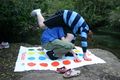
Playing Twister

Playing Twister

View from the ridge


