2008-08-20 32 -80
| Wed 20 Aug 2008 in Beaufort: 32.9932969, -80.0117545 geohashing.info google osm bing/os kml crox |
About
Located in the suburbs Goose Creek, a small city outside of Charleston, South Carolina. The geohash is located in the extreme NE corner of the graticule, between several housing developments.
Expedition
The geohash is only about five miles from Coreycubed's house. Early research of the site indicated that development in the area would differ from the street roads listed on Google Maps. Driving along US-52 towards the hash, we noticed that the rain was very intermittent. We passed through patches of rain only a few hundred yards long. On Old Back River Road, it became apparent that Cassandra Lane, which should have led directly to the hashpoint, did not exist. We looked around; there were only lower class houses and a fence backed against a new development which was not on the map. We tried to get to the fence, but the locals weren't in any mood to let us traipse through private property. We drove away from the funny looks and around to the other side of the hashpoint to approach it from the east.

Wet roads are wet

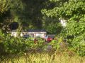
Approaching from the west side
Basketball, as we look on


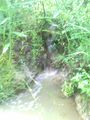
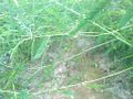
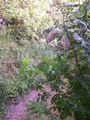
Following North Rhett Extension to Liberty Hall Road, we turned onto Barksdale Road, which was the entrance to a trailer park. The residents didn't look any more interested in strange people driving around with paper and cell phones, but we found a good place to pull the car over. Coreycubed got out and attempted to approach the hashpoint from the backside of the trailer park. Passing through a gap in the fence, he found a small stream running along the side of the park, which seemed to lead to the hashpoint. Throwing caution and dry socks to the wind, he climbed down the side and followed the stream about 2/3 of the way to the hashpoint. He did find the source of the stream while following it, but a snake blocked the path. Not dressed for snake handling, he quickly backtracked along the stream and got back in the car.
Source of the stream
About as close as Coreycubed is getting to that snake
The stream in all its glory


Not to be deterred, the intrepid duo made their way by car back onto Liberty Hall Road, turning next onto another road that led into Bradford Bend at Longleaf, a new development not on the map yet. This area was much nicer than the previous two, and we drove around on roads not marked on the map due to new construction. This got us very close to the hashpoint, though there was nowhere to exit the car and attempt to get closer. All yards were fenced off and some were still under construction. We snapped a few more pics and drove back to wash off the stream gunk and put the shoes out to dry.

Coordinates were not reached. Attempts were made on the west, east, and north sides of the hashpoint. Closest reached: North approach, 32.995430, -80.012207
Adventurers
- Coreycubed
- Anna
Achievements earned
Coreycubed
There Might be Alligators! - if not awarded for the potential alligators in his first geohash in this graticule (see 2008-08-11 32 -80), then certainly for their distant reptilian cousin encountered today!