2008-09-07 51 15
| Sun 7 Sep 2008 in Zielona Góra, Poland: 51.2259222, 15.1526692 geohashing.info google osm bing/os kml crox |
Location
Today's location is in a meadow in the village of Dłużyna Górna, right at the corner of a farm's fence. Or it may be the tree just inside the fence, Google's satellite view gave only limited resolution.
Expedition (Danatar)
10 days ago, Danatar found xkcd on the internet and, while browsing the comics, discovered geohashing. Captivated by this simple yet interesting concept, he checked the map lookup page daily, waiting for a hashpoint in a reachable distance. Today's location was only 16 kilometers (10 miles) from Görlitz, Germany, where he's currently staying for a workshop, plans were made as soon as Friday's Dow Jones opening gave the coordinates: Google Maps screenshots, route planner... but how to get there? Walking was not an option, a car nowhere in reach, so the only possibility was a bike. Sunday morning was spent trying to find a local bike rental agency. No bikes left or closed on Sundays, Danatar finally got a bike at noon, after 1.5 hours of searching. The expedition could start.
The border between Germany and Poland is in this region formed by the river Neiße/Nysa, which I crossed during my trip's first minute. Both countries are part of the European Union and since January there are no border controls; At the Altstadtbrücke/Most staromiejski/Old town bridge between Görlitz, Germany and Zgorzelec, Poland, not even a sign indicates the difference between both ends of the bridge. I continued my mission, following the route planner's easy directions (turn left, continue, turn left then right, continue, turn right, continue). It was a nice trip past fields and through a small forest. I found the farm indicating my hashpoint easily and made my way through the high grass. The farm's dog noticed me, but luckily nobody showed up, I don't know how I could have explained geohashing as the only Polish words I know are those for "beer", "strawberry icecream" and "where is the train station?". At the hashpoint I celebrated my first geohash by doing a small victory dance, marked my presence and took some pictures. I was already on my way back when I noticed I had not taken any pictures showing myself, so I returned. This time, somebody answered the dog's barking, but they didn't see me. Due to my missing stamina and because the hired bike had some flaws, the return trip seemed much longer. Distance cycled: 16 km + 16 km = 32 km
Nobody seems to have visited this graticule before. As I don't own a GPS, I hope that the photos are enough to prove that I crossed the border between Germany and Poland (photo 1) and rode by bike (photo 3) to the correct location (photos 2-5 in combination with the satellite view screenshot).
Danatar earned the Graticule Unlocked Achievement
|
Danatar earned the Border geohash achievement
|
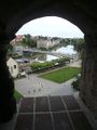
1) The bridge over the river Neiße/Nysa at Görlitz/Zgorzelec. Photo taken from the medieval city wall in Görlitz.
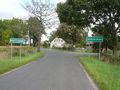
2) Entering the village
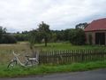
3) Overview over the farm's backyard, the hash point is at the other end of the fence. Notice the raptors inside the fence.
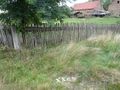
4) The internet was here...
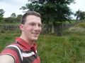
5) ...and it looks like this. My backpack should be at the correct coordinates.
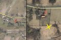
Satellite view from Google and from some Polish web site. As I didn't have a printer, I used my camera to store the maps.


