2008-09-10 -33 151
| Wed 10 Sep 2008 in -33,151: -33.2642955, 151.4566149 geohashing.info google osm bing/os kml crox |
Contents
[hide]Location
This hashpoint was located in a small parkland off the Pacific Highway, over 5km from Wyong Station.
It was actually a cleared area around 200 metres or so beyond a small planned housing development, and walking through it was only way to access the hashpoint by foot.
Attendees
Report
I missed the train from Central that I had planned on catching, before realising that 131500's trip planner has a somewhat retarded sense of logic and that I would still be on schedule even if I caught the next train - which I did. I ended up getting the same trackwork bus from Gosford to Wyong that I had planned to catch, although it was around five minutes late due to the delays of everyone getting to the bus from the train. Those five minutes proved crucial as I saw the bus I had aimed to catch to get closer to the hash leaving just as I got to the station. Beaten but not down, I figured that the 5km walk would beat the 45 minute wait for the next bus (although I was too stupid to realise there were two other ones I could have caught - they even left from the same stop).
After a visit to the local service station, I was aware that to get to the mapped area (the area covered by my Google Earth printout), I had to walk straight ahead for around 2km, then turn right and go for another 2km, before arriving at the intersection at the bottom of my map. The walk took ages, freakin' ages. My shoes were literally falling apart. The soles on both of them were flapping off and they felt like sandpaper against my socks. After I got half-way and turned right, some nice construction worker folk told me that I was on the right track, and that it was a straight walk for a quite a while (although they both scoffed at the idea of me walking there). This half of the walk seemed shorter. It was more green, less dusty and it had a much nicer feel to it. After several buses passed me by, going in the same direction, I felt like quite the moron. Nevertheless, I was too close to give up. Soon I saw what I thought was a roundabout on the distance, and I just knew that I was getting close. It turned out to be the one on my map, and after a few careful decisions I planned my exact route to the hash. I had to loop through the streets of one of those planned community/development areas, which to be honest looked extremely suburban. It was hard to believe that only a few hundred metres away it seemed like such a ridiculously rural area.
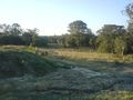
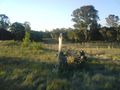
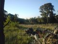
Determining the exact spot of the hashpoint was difficult, but I noticed that on the map the spot was between the trees, beyond a small clump of something in the field (it's hard to tell from an aerial shot). The rain, might I mention, had turned the otherwise beautiful green grassy area into something more muddy and unpleasant. Either way, there was a vertical log/tree thing in the same spot as the clump, so that must have been just before the geohash point. I walked over to the hash between the trees and took some photos. Unfortunately, the shadows cast by the trees made for some pretty bad shots, so I walked back to the log and took some much better ones. I walked around for a little more (drew an XKCD in the sand) before going back the way I came. The bus stop was practically right in front of me when I got to the intersection, which was a pleasant surprise, and the ride home was a little darker but still alright. I left for the hash just before 1pm, and got home just before 9, hitting the hash at the chronological halfway (just before 5pm - at least according to the EXIF tags on the photos).
Google Maps Street View is provided on a few of the photos, although if you notice the parting in the trees in the ones taken from the hashpoint, they're the only proof I really need.
Gallery
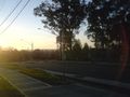
Getting to Wyong
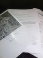
Helpful 131500 and Google Earth printouts.

Leaving Gosford for Wyong by bus. (proof)


Getting to the mapped area


The hashpoint
Love at first sight.
The glorious hashpoint - almost there.
A great shot of the hash.
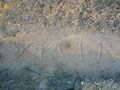
x marks the kcd.
The beginning of the end.


