2008-10-02 49 9
| Thu 2 Oct 2008 in Würzburg: 49.9332127, 9.8884438 geohashing.info google osm bing/os kml crox |
Location
Today's location is in a forest near Retzstadt.
Country: Germany; state: Bayern (Bavaria, EU:DE:BY); administrative region: Unterfranken; district: Main-Spessart
Expedition
Danatar
When I saw today's location on Wednesday evening, I was thinking: "Only 20 km away and less than 300 m of altitude difference to get there, this will be a nice trip before lunch." I set out early in the morning and the "nice trip" turned horrible.
There were steep climbs, bad roads, not-very-steep-but-very-long climbs, very bad roads, strong headwind... I was no fun at all and I was almost thinking about claiming the MNIMB achievement, but then I'm just a pussy without any stamina. I had troubles finding the correct roads and for a long time I was not sure about my direction but somehow I was always on the right path. On the last kilometer (see satellite view picture) there was no road at all, only vague signs that somebody passes there once in a while with a tractor. The area seems to be good for hunting because I saw 8 or 9 raised hides there. At the hashpoint I had to eat half of my chocolate provisions to regain energy.
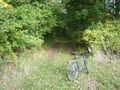
For the first meters of my way back I took the road shown in picture 4 because I didn't want to wade through high grass again. The return trip was not much easier as I now had to climb the other side of all the hills, only the very-long-climb was now a nice long downward slope. Total distance cycled: 20.2km + 20.5km = 40.7km. Total uphill distance: 540 m
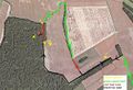
Satellite view: Road quality (green, red, black) of the path I took (arrows) and the places the photos were taken from (yellow, arrow indicates direction of photo)
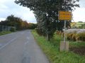
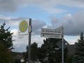
1) Güntersleben town sign. 10 km from the hashpoint, but I didn't pass through any village more close.
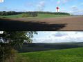
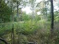
2a) Overview over the hashpoint's forest. 2b) View from the edge of the forest back to where I came from.
3) 155 large steps straight ahead to get to "4" OR 50 large steps straight ahead, then 50 large steps into the undergrowth to get to the hashpoint.
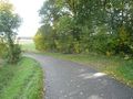
4) 155 large steps straight ahead from picture 3. There's a road here, why did I take the cross-country trail?
5) Not visible from the satellite image: Young trees some meters from the hashpoint.
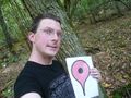
6) Coordinates reached (some meters more or less because no GPS). No stupid grin today, instead insane gaze.
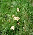
Perhaps these lil fellers could have eased my suffering...
An Onymus is commemorated here, I wonder who he was.


