2008-10-19 48 12

| Sun 19 Oct 2008 in 48,12: 48.5790317, 12.3253218 geohashing.info google osm bing/os kml crox |
Tomcat
In the morning I realized that my to todays trip, if I would use another than my usual route, would bring me next to the 48 12 hashpoint and the location on Google Earth looked quite easy to reach. So spontaneously I decided to try to go for it.
When approaching the region from north, the giant steam cloud above the nuclear powerplant of Niederaichbach was visible from many miles away in the morning mist.
Reaching the hashpoint finally turned out to be a bit difficult: the dirty road behind a farmhouse, called Hutzenthal, west of the hash, leading almost directly to it, turned out to be very dirty and muddy and seemed to be private property. So I tried it again from the east, via Paring, again ending up on a unfastened dirty road that lead me to a meadow at the top of a hill east southeast of the hashpoint. From there I walked down the final 400 m to the hashpoint, at first across the meadow than through the woods, always gazing at my GPSr.
Thus I reached the hashpoint at 11:00. GPS-reception was rather weak underneath the trees, so i stumbled around for some minutes to find the correct position. Just as I was taking the usual pictures, a voice shouted in a rude an rather hostile manner what I was going to photograph there? I looked up, answering in the same unpolite way "The woods", and saw a man and, some twenty meters away, a woman, both looking like forest officials. So I quickly stowed away camera and GPSr and left the place.
Photos
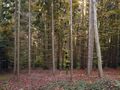
The hashpoint in the woods.
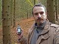
Tomcat at the hashpoint.
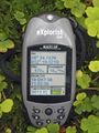
Moos, clover and a GPSr.


