2008-10-24 49 9
| Fri 24 Oct 2008 in Würzburg: 49.8808196, 9.9452232 geohashing.info google osm bing/os kml crox |
Location
Today's location is in the Gramschatzer Wald forest, not far from Rimpar and Güntersleben. The hill is called Binsenberg and is covered mostly in beech trees with oaks and a few conifers.
Expedition
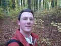
Danatar
The hashpoint is only 0.08° latitude from Danatar's home, so he decided to cycle there before lunch.
The road had a bicycle track next to it until Rimpar, which I knew from another expedition, the rest was part highway and part forest track. Navigating in the forest without GPS is difficult, but I took the track visible in this map (Bavarian Land Survey Office and I'm sure that I got within 50 metres of the hashpoint.
I took the same way back (without the bit where I did not take the correct turn) and arrived exactly at lunchtime.
Distance cycled: 14.2 + 13.6 =27.8 km. Top speed 53 km/h downhill on the highway, 45 on the forest track near the hashpoint (covered in wet leaves but not as dangerous as it seems, it was a straight part).
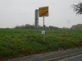
Leaving Rimpar
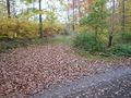
Not far now, you can see the edge of the forest between the trees, picture taken from here to the west.
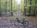
A muddy forest track starts here, it can be seen in the Bavarian Land Survey Office's map. I took 140 steps to the intersection, then followed the track to the right for another 80 steps.
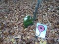
Randomly placed somewhere near the first "e" of "Binsenberg" in the BLSO's map.
Coordinates reached


