2008-10-31 49 10
From Geohashing
| Fri 31 Oct 2008 in Bamberg: 49.7980240, 10.0469395 geohashing.info google osm bing/os kml crox |
Location
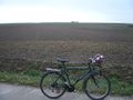
Today's location is in a harvested sugar beet field near Rottendorf.
Expedition
Danatar
I took the Great Eastern Geohashing Bike Track (which is my main access to this graticule together with the Great Upriver Geohashing Bike Track along the Main river) until Rottendorf, then I took a track I haven't been on before and reached the hashpoint shortly after, getting my feet muddy. Some pictures, return trip, all in all 70 minutes home-hash-home. I forgot to take a picture of the Rottendorf town sign or a street sign. Distance cycled: 9.5 km + 9.1 km = 18.6 km
The hashpoint is right there in the mud
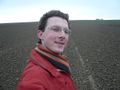
Coordinates reached
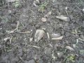
Sugar beet residues


