2008-11-18 48 9
| Tue 18 Nov 2008 in Stuttgart, Germany: 48.4852361, 9.1656442 geohashing.info google osm bing/os kml crox |
About
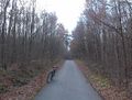
The hashpoint is at Reutlingen, in a forest area between Ohmenhausen and the city centre, almost exactly on a well travelled bike and foot path.
Expedition: Ekorren
Only three days after saturday's hash at Kusterdingen, another one came really near - i.e. less than ten kilometres from my home, and also accessible. So, when I saw the coordinates yesterday, this was a good reason to grab my toolbox and fix the bike.
First stop was after only a few minutes when I remembered what I had forgotten to pack (you see, it's never the if but always what). The thing I'd probably need and didn't pack was the prepared hashpoint marker. I shortly considered turning around but as the luggage check surfaced that I hadn't forgotten notebook and pens I decided to make a new one at the destination instead.
Second stop after two km was for a loose screw - nothing uncommon with that bike, and no reason to go for train wreck consolidation price. Actually I had the neccessary tools in my backpack, so after a short stop I had it fastened and went on.
Around 12:30 I left town and took the new bicycle route through the Ehrenbachtal, which features a covenient slope of between 2 and 5 % except of a very short part, compared to >10% on the shortest route, which isn't really so much shorter anyway. As usual I missed a turn at Immenhausen, the next road was blocked by a truck almost as wide as the road and impossible to pass, so a small detour through Mähringen was unavoidable. When leaving that village for Ohmenhausen, the road was barred with a sign "road closed but open until the building site". Well, it's usually not so much of a problem to pass a building site by bike unless they haven't rebuilt a missing bridge yet, but as there are no bridges on this road I didn't expect them to effectively bar it so I happily passed that sign. Actually, a few hundred metres later, at the next crossroads, there was the same sign barring the road from the other side but nothing like a building site inbetween. Maybe they plan to start building in 2011 and already put up the signs? I went around Ohmenhausen, crossed the industrial area and found an agricultural road which brought me to the small road the hash was on, and arrived at the hash around 13:30.
Finding the exact place was a bit difficult due to poor GPS reception in the forest, so I needed to wait some time but I think it's fairly accurate now. Another problem was pedestrians traffic as I didn't really want to need to explain Geohashing to curious 70 year olds. So it took quite some time to prepare markers, make photos and leave a book. Left the site around 14:00 and headed for a nearby geocache. Which got me on heavy detours on mud paths, but I found it in the end, and then turned back home along another route so that I'd be home before dark.
Achievements:
Of course it's another bicycle expedition, but more interesting, it's a Déjà Vu Geohash. The hash is on the path (within inaccuracy of google maps), and I have taken this path several times before when going by bike to Reutlingen. Though, I can't exactly prove it but only make it plausible. I may be able to prove that I went from Ohmenhausen to centre several times in the past (e.g. if one would look through all of my past bookcrossing releases, there are a number of pairs with one release at Ohmenhausen and the next one not much later in the centre), and there are witnesses that I took the bike for these trips. But although this route is probably the most reasonable to go, there are other, so you will have to believe me. I hope to get a better Déjà Vu Geohash later.
At the hashpoint
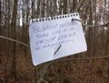
Paper marker
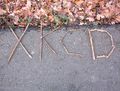
Wooden marker
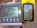
Date, time and coordinates of the hashpoint, temperature of some warmer place.


Ekorren earned the Bicycle geohash achievement
|
Ekorren earned the Déjà Vu Geohash Achievement
|