2008-11-20 50 9
| Thu 20 Nov 2008 in Fulda: 50.0567020, 9.6033959 geohashing.info google osm bing/os kml crox |
Contents
Location
Today's location is in a forest near Langenprozelten. The next bigger towns are Gmünden am Main and Lohr am Main, between
A story in 4 parts by Danatar
Prologue
Some of Danatar's friends have reached the end of their studies during the last two weeks, so there has been a reason for champagne and sparkling wine almost every other day. Today, the last future doctor had to take the final step and Danatar had prepared another bottle. The location of her oral examination was the hospital in Aschaffenburg, 80 km from Würzburg. She didn't expect anybody to come, but Danatar likes to surprise people, he only had to get there.
A ticket from Würzburg to Aschaffenburg and back is 30 Euros (US$ 37) for the standard trains or 40€ for the faster trains, if you don't own a BahnCard which gives a 50% discount. But for 19€ (single person version, 27€ for a group of up to 5) you can buy a Bayernticket, which allows as many trips as you like in the state of Bayern (Bavaria) in one day (the same is available for every other German state). You are only allowed to take the standard (i.e. slooooooow, with stops in each and every village) trains, though. With this ticket, Danatar could get off the train, visit the 50 9 hashpoint (which is not far from the railroad line) and continue to Aschaffenburg with another train.
Chapter One: Multihash?
If you own a ticket which allows limitless trips, why not use it? The 50 10 hashpoint is not far from Haßfurt train station. The train schedule gave me: Start at 8:36, arrival in Haßfurt at 9:17, 1 hour 24 to cycle the 2*10 km to the hashpoint and back, the return train at 10:41 is in Würzburg at 11:37. Enough time for lunch before going to Aschaffenburg.
As I already told, today was not the only day for celebration. At 7 am, I made the following calculation:
For the given values
alcohol = true ; sleep = <4 hours ; weather = cold and rainy ; plans for today = +alcohol and -sleep
my personal geohashing formula read
bed.warmanddry > geohashing.newgraticule
Chapter Two: Journey to Aschaffenburg
I took the 12:30 train and got off at Langenprozelten train station at 13:08. I set out for the hashpoint on foot in the light rain. Most of the way was on paved tracks or small streets, but for one kilometre I had to follow a highway without a sidewalk. After 50 minutes I was on the forest track near the hashpoint. I tried to count my steps from the last intersection, but I miscounted a few times so maybe I was off by up to 50 metres. From a spot which resembled the satellite image I took 20 steps into the underbrush (my shoes were already muddy) to the hashpoint. I took some pictures and walked back. This took me another 50 minutes so I was at the train station at 3 pm, in time for the next train to Aschaffenburg (which goes once every hour).
Chapter Three: What am I doing here?
I arrived at the Aschaffenburg hospital shortly after 4 pm. With the exams usually ending between 5 and 6, I visited my erstwhile wards and had some chats with my colleagues. Only when I met the neurology chief physician (who is one of the examiners) did I find out that the examination had ended very early and that my friends had left long ago. So much for the surprise. I could not reach them by phone so I returned to Würzburg, where I arrived at 18:40.
Chapter Four: Multihash!
This is the report for the 2008-11-20 50 10 expedition
Now without any plans for the evening and still with the all-you-can-travel ticket in my pocket, I decided not to stay at home. A short check of the train schedule gave me the following timetable: Start at 19:33, arrival in Haßfurt at 20:16, 1 hour 45 to get to the hashpoint and back, return train at 22:01, back in Würzburg at 22:53. I took the tramway home, grabbed a bite and my bike and rode back to the train station, where I bought a ticket for my bike.
In Haßfurt my compass told me which direction to take (yay for a compass if there is no sun to navigate by) and I set out. The first part (inside the Haßfurt town limits) was easy, but that changed. It was dark (surprise! It's 8 pm in November), it still rained (surprise! It's November) and the only road was a minor highway with no bicycle track (surprise! It's the Bavarian outback, nobody goes here by choice). But I continued into the regions unknown to civilized man, checking my rear light every minute (how should I explain to the surgeon that I got run over in Haßfurt while living in Würzburg... Do they have doctors in this part of the world at all?).
I had a few moments of "am I lost?", but (with not many wrong turns there to possibly take) I finally found the track near the hashpoint after 50 minutes (including those minutes of jumping up and down on my odometer for not working). As it was dark and wet and nobody would ever find my body, I refrained from stepping more than a few steps between the trees with only my mobile phone to light the way (no batteries for my torch left). I tried to take pictures, but my camera's flash is one of the feeble kind so there's not much to see on them. Half an hour later I was back at the train station and had time enough to eat a Döner before my train to Würzburg came, where I arrived shortly before 11 pm.
Epilogue
(There has to be an epilogue because there is a prologue.) Danatar's last expedition was 19 days ago. That's a lot of not geohashing after 10 expeditions in October so he really needed a double dose to calm his nerves.
Achievements and pictures
It's a Public Transport Geohash and the first part of a Multihash (2008-11-20 50 10). I walked about 10 km (but it's not a Walk Geohash).
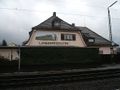
Langenprozelten train station
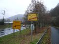
Langenprozelten town sign
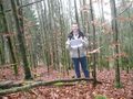
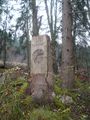
Coordinates reached
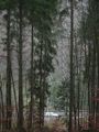
Electrical pylon near the hashpoint. I think it's the 50.0580 9.6045 one, if not then I was at the wrong location.
BaySF = BAYerische StaatsForsten (Bavarian State Forests, the public agency responsable for the Bavarian forests)


