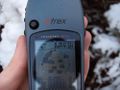
2008-11-22 48 9
| Sat 22 Nov 2008 in Stuttgart, Germany: 48.4655210, 9.0221575 geohashing.info google osm bing/os kml crox |
About
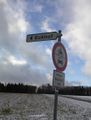
Today's hash was still on the area of the town of Tübingen, in the Rammert forest near the Hofgut Eck farm (shown on google maps with the funny but wrong name "Eek"). Although the Rammert isn't really a large forest, it's known for being a maze of twisty little dirt roads, in which, though not all alike, people frequently lose their sense of orientation. This is of course known by the various map services, map printers and the forest authority, so they take huge effort to draw waynets for the forest, none alike. They all show a lot of creativity with this. So, if going there, it's always a good idea to bring a few kilometres of string or some GPS to help you not getting lost.
The weather forecast was horrible, there should be snow and strong wind.
Ekorren and Nick_mz agreed to shift the official time to 14:30 this time and published it on the graticule page, thus making it possible to attend the first real meetup in this graticule.
Expedition: Ekorren
For the fourth time within of eight days, the hashpoint came within of a ten kilometre radius of my home - what are the odds?
In the evening it was cold, raining, storming, and my bike had a flat tyre.
In the morning it was cold, snowing, the tyre was fixed and the keyboard of my computer had died.
Around noon it was still cold, currently no fallout visible in the sky, the keyboard was replaced and I was able to read the note from Nick_mz confirming that he would go. So this meant, whatever the weather would be in the afternoon, I would also try to get there.
I estimated that it would take me about half an hour to get to the location, so, to be able to get some food on the way, I left at 13:45. I lost some time due to queues at the shop but seemed still to be on schedule when reaching the lower end of the slope to Kressbach. Lost some more time sneaking up the mountain, and when I finally reached the upper end I found, apart from a really lovely view to the snowy Schwäbische Alb mountains, that I most probably would be late. So I dropped the plan to take more photos on the way and raced the remaining kilometres in neck breaking speed towards the hash to be at least almost in time.
Shortly after the announced time I came near the hash, stopped my bike and tried to find the hashpoint which should be about 30 metres from the way. As my GPS isn't quite the newest generation, and there were mountains, and there were trees, and there was snowfall, the GPS was almost as clueless about where to leave the way as I was - but then suddenly a figure emerged from the shadows, and it was Nick_mz, and he had already scouted the place.
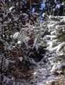
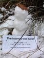
We climbed down, stumbled through the snow covered forest and, at a place where both of our GPS mostly agreed to it being very near, decided to have reached the point. Down there in the valley there was even more snow than up on the plains, so we could gather enough to build a small snowman and leave it on the hashpoint. While we took photos, the weather cleared up for a moment, leaving us in a sunny winter forest.
We gave the marker to the snowman so that he would have something to play with, alone as he is, and then left the place as we didn't expect anyone else to come.
Nick_mz had to catch a bus from the next village, so we walked down there, and when he entered the bus, I started by bike and with really cold fingers now as I had lost a glove and the weather had turned back to wind and snowfall again. Nevertheless, I caught up with the bus and tried to take advantage of it's slipstream for my trip back - but had to give up when the bus reached 45 km/h on a road with a speed limit of only 30.
Expedition: Nick_mz
I took the bus to Bühl an walked approximately 3,5 km to the hashpoint. The way back was not only shorter but far more comfortable to walk under today's weather conditions (Thanks to Ekorren's superior knowledge of the place).
Gallery
This way!
Brrrr... why is that white stuff so cold?
Who's cold? I'm cold!
Looks like I'm quite there
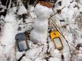
This snowman pretty much knows, where he is.
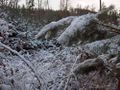
I took that way to the hashpoint.


Achievements
Ekorren and Nick_mz earned the Snowman Geohash Achievement
|
Nick_mz earned the Earliest geohasher achievement
|
We don't seem to have the full proof for the next two - no thermometre, and no picture of both of us:
Nick_mz and Ekorren earned the Frozen Geohash Achievement
|
Ekorren and Nick_mz earned the Meet-up achievement
|