2008-12-12 48 9
| Fri 12 Dec 2008 in Stuttgart, Germany: 48.4561421, 9.3386124 geohashing.info google osm bing/os kml crox |
Contents
[hide]About
The hash is located on a field at the edge of the village Würtingen, which is part of St. Johann community, on the Schwäbische Alb mountains, about 710 m above sea level. It is easily accessible if you go there by bus in summer. According to the skiing report for the area, which announced first class conditions for both downhill and cross country skiing, it wasn't exactly summer at the day of the hash, though.
Expedition: Ekorren
The weather forecast was promising: No more snowfall during the day. Which was a considerable improvement from the days before.
So, here were my plans: Start around 10 am, take the Ehrenbachtal trail to Mähringen, the shortest way to Reutlingen, buy a thermometer from a discount shop on the way (for the Frozen Geohash), continue to Eningen and climb the mountains on the Lindenhof trail. Estimated distance: 30 km (one way). Estimated time: Less, but not much less than three hours. Check the terrain if you think that's slow.
I was prepared for some obstacles, and I shouldn't be wrong with that...
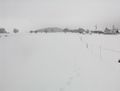
I set off at 10:45 so I was not even an hour behind schedule for a start, and reaching the borders of the town I found - snow. Well, there also was snow inside town, but it was definitely more outside. The chances to get stuck already on the first slope seemed pretty high - so I turned around and chose another route, a small and very steep road. But this one was mostly cleared of snow so it actually took me up to the Härten plains. I raced over a snowy path to Mähringen and got back on my favourite trail.
For a few hundred meters, then it turned from clear to the ugly kind of ice and snow where you'll go with pedestrians speed in first gear on flat terrain, putting all energy into crunching ice, plowing through snow, and balancing. Again I turned, went for the main road this time and got (with only little more obstacles) well into and through the city of Reutlingen, forwarding for Eningen and stopping several times to shop for a thermometer (failed), food (succeeded), while trying to ignore the sweets displays (failed).
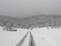
Would the Lindenhof trail be passable? This was rather questionable as it's no public road for motorized traffic. It is the internal connection between two parts of a research facility so I reckoned the people working there would probably keep it available. Fooled by a surprisingly good road to the lower facility, I went there only to find that the way behind it was in even worse shape than the one at Mähringen. I tried to continue uphill but soon got stuck, knowing that the slope would soon change from gentle to steep, then from steep to crazy, culminating in a >20% section shortly before reaching the top at around 710m above sea level. No way this way. Turn around, foolish biker.
A bit more than half an hour after leaving the town centre I was back again to Eningen. Now being way behind schedule, it had to be either the main road or giving up. Giving up isn't an option, so the main road it was, sneaking up three hundred more elevation meters, pestered by motorists waiting for a chance to overtake. At 755m the worst was done - I had finally reached the plains. Only a few more kilometers to go and I'd get to the village.
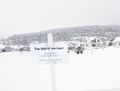
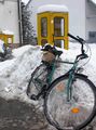
The hash itself was on a field as expected, though there seemed to be more houses around now. Luckily it was not one of the many fenced fields, but there was less luck with the snow: Only 40 meters to go from the next road, but through a 30 cm thick layer of untouched white mayhem. A sleigh, a tank or a raptor mount would surely come handy now. Sadly, I had none of them, so the only chance was to walk in, and I got there at 14:40.
Well, neither my fingers nor my feet were exactly dry or warm before, but now the shoes also got snow inside, and the feet got really cold. So I restrained from building a snowman in the field, hanged the marker on the next fence post, and hurried into the village centre. Next task: Find a postcard. Failed. There was a surprising variety of shops in the village, but none of them stocked postcards of the area. Can you believe this place wants to attract tourists and they don't even have postcards?
My task was fulfilled, I only had to get back home. Kept on the main roads this time (different route, anyway), got even more wet after a fall into wet snow when trying not to collide with a car suddenly appearing from nowhere, reached Reutlingen at sunset, and after some more shopping (no thermometer, again), went home in the dark and another frozen bicycle hash was done.
Bicycle geohash technical data:
Home -> hash: 40.13 km
Total length: 77,3 km
Lowest point: ~310m
Highest point: ~780m
Summarized significant uphill slopes: ~700m
Gallery
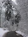
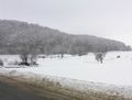
The winter forest was really beautiful
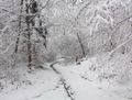
This way? Might be passable.
This way? Better not.
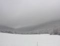
The hash must be somewhere up there in the clouds.
The bike trail up, or rather: A road less travelled.
Turn around, foolish biker!
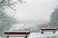
A short break on the slope, and a view back to Eningen.
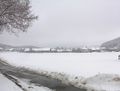
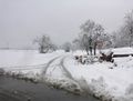
Somewhere behind these houses
I'm dreaming of a white hashmas.
Out there.
Another view near the hash.
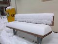
A soft cushion
This is neither a sleigh nor a snowmobile.
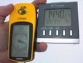
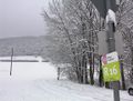
Coordinates, date, and as usual a totally inaccurate temperature


Achievements
For the third time in a row, I can't prove the Frozen geohash with a thermometer photo. The clock shows a temperature of +1.2°C but that thing is total crap. Last time I threw it into snow for a while I got it down to +9. So when it shows 1.2, this probably proves sub-zero. The forecast expected a highest day temperature of not more than -2°C for this area, but there seems to be no official station nearby to check the final value. Also, the snow and ice on my bike never thawed.
Would you think this expedition qualifies for a MNIMB geohash? The obstacles were mostly rerouting several times, the fact that the field was covered in 30 cm of snow, and, of course, those hundreds of elevation meters. Anyway, apart from the second, these obstacles were due to the fact that I did it as a bike geohash. Using public transport or a car it would have been much easier.