2008-12-17 48 9
| Wed 17 Dec 2008 in Stuttgart, Germany: 48.4629612, 9.1672532 geohashing.info google osm bing/os kml crox |
About
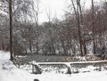
The hash is in the forest area Eichwald at Reutlingen, between the centre and the incorporated villages of Bronnweiler and Gönningen.
Expedition: Ekorren
Ten kilometers as the bird flies - this was too close not to be tried. Only, the weather... it was about 0°C, and it had rained all morning, then changed to frozen rain in small grains. The forecast, however, promised that the rain, snow, hail or whatever it should be called, would get less in the afternoon. So, when the clouds stopped dropping dihydrogenium monoxide for a while, I went. This should be, including some shopping on the way, a trip of not more than two hours, on known paths except of the last few hundred metres into the forest.
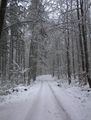
Since it hadn't snowed much for a few days, and the snow and ice on the ways was mostly gone down here, I reckoned that the shortest and usually most convenient route via the Ehrenbachtal valley and Ohmenhausen should be viable today. Well, somehow it was, but very convenient it was not, for there was still a lot of ice on the way, though not enough to keep me away from it. Anyway, I'm sure it was the right decision not to take this track two days ago, and it definitely wouldn't be a good idea to take it downhill. Now it was just slow to go, but acceptable. I continued without further obstacles to the border of the hash forest.
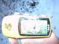
Reaching that point, I noticed how ill prepared I was - I had neither packed a map or a printout nor a compass. All I had was a GPS that hasn't both of it either, the coordinates and a vague memory of the map. The GPS showed 800m to the hash, a number that wouldn't significantly change on the next kilometer. So I guessed for directions and plowed my way through layers of ice and snow at a neckbreaking speed of between 5 and 10 km/h, desperately trying to keep the bike and me on track. And, as it turned out, I hadn't guessed too bad and came near the hash. The GPS had very poor reception and couldn't really decide where it would be, but it seemed to be very near to the way at least. So I decided for a spot, built a snowman, gave him a sign he could proudly hold, and set off for the way back.
For a number of reasons I didn't want to take the same way back but leave the forest more at the upper part. So, further up the way I had taken to the hash wouldn't be too bad, but then? Finally I found a waypoint at the village of Gomaringen in the GPS, so I could keep the general direction. And went on with guessing, and after almost half an hour I had crossed that white mayhem and got to the landfill, which had a connection to the main road.
In the meanwhile it had started snowing, and the bike trail to Gomaringen which I had intended to take didn't look viable at all. Also the main road was now covered in a mixture of snow, water and dirt, time went mercylessly towards sunset, and it continued snowing, obscuring any sight on the road that laid before me, and it started to get slippery. Somehow I made it on the main road to Gomaringen, took a short warm-up in a supermarket, and raced on through the snowy mayhem back towards home, taking the main road as long as possible and then the bike path, more knowing than seeing where to go. I arrived with the last remains of daylight which was just lucky as the bicycle light is mostly useless under these conditions.
What should have been a short and easy trip of less than two hours, had taken three and a half. I arrived soaked from snow, mostly frozen, only kept going by the prospect of a warm and dry home. Another adventure in the spirit of geohashing had succeeded.
On the way
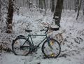
Near the hash
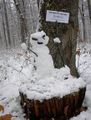
Snowman and marker
Here it is
Bad proof photo


