2009-01-05 -37 174
| Mon 5 Jan 2009 in -37,174: -37.0151378, 174.5361555 geohashing.info google osm bing/os kml crox |
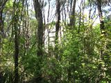
In the waitakerie ranges 20m in the bush from Donald McLean Track. At an altitude of 320M according to Open Street map (but was closer to 220M) To get there take a road (starts at -37.021178, 174.540150) to a car park at -37.014417, 174.537888 and take the track from there.
Contents
[hide]Plan's
TunezNZ
Planning to drag along two friend's and someone with a full licence and a gps, Drive to -37.025815° 174.530435° and from there walk up Puriri Ridge track 1.7km to a hut about 40m off the track then walk for 20m more to the Hash location.
After further investigation the better option is to go to the aforementioned car park and enter there (as where we had planned to enter the track is 30 m into dense bush up a steep hill off the road)
Expedition
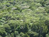
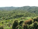
Jono and Tunez left home at 11.30 and had to stop in at Dick Smith Electronics to get a UHF radio set, Out of there by 12 and on to the next place of call (VTNZ) to burn a hole in my pocket and pay for my car registration ($221.22) So finally at 12.40 we are on the road heading to the hash site, We only got lost twice but after asking some friendly locals we were back on the track, heading further along the coast the road end's up coming into single lane country and then into gravel roads. Eventually we get to the car park at 14.15 and head out to the hut, this was found easily. Ok, now out with the compass and let’s find where this is. Hmm, 20 big steps that way into the fairly dense bush, wooh we got here, only took 5 minutes, Photo time. Seeing earlier the look out the other side of the car park we go for a walk, wow, it gave us 360 Views we could also see the hut from up here. Alright time to go home, with easy traffic and only 1 near miss (damn idiot driver's) we where home by 16.20, This was a fun expedition fairly warm today, according to met service 22C a good location too.
Statistics
- 130Km of driving
- 600m of walking to the hash, walked an extra 1300m to the look out
- 5 Hours total
- $4.80 of food
- 3/8th's of a tank of fuel
Photo's
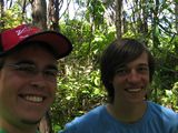
The Grin
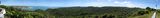
Pan from West lookout over the hash
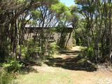
Coming up on the hut
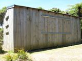
The hut
The hut as proof of location
From the lookout to the hut
Look in the very center
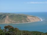
The south clifs of the manakau heads


Ribbons
TunezNZ & Jonootto earned the No Batteries Geohash Achievement
|
Tunez
TunezNZ earned the Land geohash achievement
|
TunezNZ earned the Drag-along achievement
|
Jonootto
Jonootto earned the Land geohash achievement
|