2009-01-05 49 8
| Mon 5 Jan 2009 in Mannheim: 49.0151378, 8.5361555 geohashing.info google osm bing/os kml crox |
Location
In a forest close to Pfinztal-Berghausen (near Karlsruhe). Just about 100m from the road B293.
Expeditions
Fluxkompensator
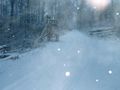
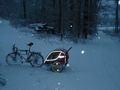
In the afternoon, I went to the today's geohash location by bicycle and child's trailer (including child ;-)). The weather conditions were challenging as it had started to snow in the morning. Another thing, I did not realise looking on the satellite photos of google maps before I started, was: I chose a route going over the Hummelberg. Climbing the Hummelberg, I took a road which was not ploughed(?, from the snow) at all. That wouldn't have been a big problem if it wasn't for the ice underneath the snow (remainders from the freezing rain on New Year's Eve). Due to the slippery underground, there was absolutely no way to ride my bike (with trailer), and it was even very, very, very hard to push the bike uphill. Somehow, and quite slow, I made it up that hill and later at about 16:45, I reached the geohash as it already started to fall dark. On the way back I took another route. :-)
Do I somehow get some extra points for going to the hashpoint by bike? Through the snow? With bike trailer? ;-)
A stand about 80m from the hashpoint.
View to the west about 60m from the hashpoint.
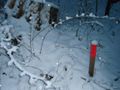
A metal picket few meters from the hashpoint.
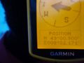
Display of the GPS at the hashpoint.


