2009-01-26 48 9
| Mon 26 Jan 2009 in Stuttgart, Germany: 48.5419127, 9.2552425 geohashing.info google osm bing/os kml crox |
About
The hash is in a forest near Metzingen.
Expedition: Ekorren
It was a sunny winter day, with temperatures up to +4°C. The days before had been rather warm and, partly, also very rainy, so even in the forests and valleys, the snow and ice were gone. If there had been a little bit more green, and the air had been a bit more warm, one could almost believe it was spring. Actually, it wasn't.
It was already almost noon when I got on my bike and hit the road. Once again, the journey started on the Neckartalweg, a rather good (though it could be much better if they actually would talk less and build more) long distance cycle trail. Following the valley, with no significant slopes, it would be only about 320 km to get to todays hashpoint in the 49,8 graticule. Well, that may be a bit too far for today.
So I swapped two digits, aimed at 48,9 instead, and left the valley already after only about 15 km. I chose a route which was a bit of a detour, for several reasons: There were some significant ways missing in OSM, there was the final of a mystery geocache I had solved ten months ago but never actually searched, and it would get me around any main road.
After about two hours, I reached the borders of the town of Metzingen.
Metzingen is a well known place, and recieves a daily share of busloads of day visitors which is much larger than that of many of the touristical places you'll find in any guide. Suabians just go there from time to time. It's where they spend their money for a warm feeling to have saved some money. It doesn't matter whether you need what you buy, it doesn't matter whether it would have been cheaper somewhere else. You will buy it here.
It's the temples of the Sales. It's the city of discounts. It's the worship of the percentage sign. They are everywhere. This town is the largest aggregation of factory outlets in southern Germany.
Reaching the borders of the town now, with a view on all those new concrete and glass temples, I turned half around, and went back up the hill, to reach our place: The sacred grounds of the algorithm, the site of the coordinates, the place of the hash. And near I got on a rather good track, but if it had been on the track, it would have been too easy. So there were still about fifty metres to go when I had to leave my mount, and continue on foot into a dense forest. But the place couldn't hold me off, I found my way through the underwoods.
Well, there wasn't anything useful to do here, so after taking a proof photo I went back, crossed the town at it's limits this time, kept out of the worship commercial area and went for a larger detour to visit some surrounding villages for some significant OSM mapping and an ongoing bookcrossing challenge. Went up a not too high mountain which offered a magnificient surround view. Got talked to by several people who couldn't believe that there actually are people doing a bike trip of more than a few kilometres on such a cold day (heck, it was above zero and no snow - compare that to some earlier expeditions!). And finally reached home again with the very last ray of daylight.
Waterhash, anyone?
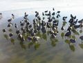
Walk waterhash, anyone?
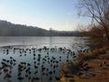
It's actually the same lake as here
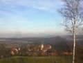
Just a view visited later
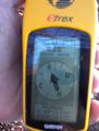
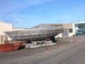
The coordinates
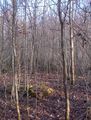
The hashpoint itself
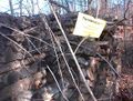
The marker (50m off, near the track)


