2009-01-28 49 8
| Wed 28 Jan 2009 in Mannheim: 49.4462001, 8.8479133 geohashing.info google osm bing/os kml crox |
Expedition
ilpadre
Expedition total: 5 hours, cycled 55 km
Watch the expedition video!
At a first glance, I did not want to go to the hashpoint. The place was an open field near the top of a mountain, 15 km from Heidelberg as the bird flies and 25 by roads, so remote that the nearest bus stop is at 5 km distance. There seemed to be no way I could go there - until I thought of my bike. My bike is a three-speed Hollandrad, held together by rust and black paint and it is the last option I would consider for a 55 km trip. But there were no other options.
To be back home before sundown, I started at 10:30, equipped with maps, a peanut butter sandwich and a liter tomato juice.
Heidelberg - Neckarsteinach (km 0 - 16,5):
The route led along the Neckar valley in the Odenwald hills, a picturesque waterfront with beautiful castles and impressive formations of the characteristic red sandstone those castles are built of. Being the region's major recreational route, the bikeways were well maintained and pleasant to cycle on.
Neckarsteinach - Schönau (km 16,5 - 22,5):
At Neckarsteinach, I had to turn left to reach Schönau via a beautiful valley formed by the Steinach, a tributary of the Neckar. An asphalted cycling path led along the riverside, separated from the street leading to Schönau by more than hundered meters. I did not have to pay attention to anything but the soothing sound of flowing water. Schönau is German for "pretty meadow". Indeed it is.
Schönau - Grein (km 22,5 - 26,5):
Etymologically, the German grein derives from the same word as the English groan, and that's pretty much what I did for the next hour. Schönau is at 180 m, Grein at 360 m, and the hashpoint at 442 m elevation. That's an average slope of 5,5%. I moaned, groaned and sweated and managed to cycle the first two kilometers, but as the slope became steeper, I had to give up and wheel the bike until the forest thinned out and I finally saw the first houses of the small village of Grein. A flock of Suffolk sheep greeted me with eyes of simple-minded curiosity.
Grein - Hashpoint (km 26,5 - 27,5):
What I thought would be a short ride proved to be a long walk. I wanted to approach the hashpoint from the easier south-eastern side, but as I approached a house after the first 500 m, I saw a dog running towards me. A big dog. That barked. Loudly. There was no fence around the property, and soon my bike was the only thing between me and a textbook example of a dog's guarding behavior. He very effectively convinced me to turn around and get away, trying my best to move slowly and avoid any eye contact.
To reach the hashpoint from the south-western side, I had to shove my bike up a steep hill. I passed by a small chapel and some benches that granted a beautiful view of the Odenwald. When I approached the fields surrounding the hashpoint, I realized I was lucky the field was not guarded by an electric fence, as many of the other fields were. Not that a fence would have stopped me after all I went through. This time of the year, there isn't even something to protect or to fence in - the crops are all harvested and the cattle is someplace else.
A lot of deer must have died at the hashpoint, since it was within viewing (and shooting) range of three deer stands. I spent a short time mourning and walked back to my bike. This time I did not forget to leave my hashtag at a nearby fence.
The Way Back:
It was all downhill until Neckarsteinach, but I walked every few minutes until I reached Schönau to not overheat the brakes. When I reached Heidelberg, I felt exhausted, much of this being mental tiredness as well as physical exhaustion. I'm glad I chose to go hashing over a lazy day at home, and I'm already excited about what other interesting places geohashing will lead me to in the future.
Hashtag
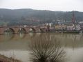
Passing by Heidelberg's most famous sight
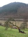
Poor tree!
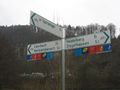
Part of the official Prague-Paris pan-European cycle route
"Jesus lives in me"
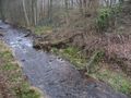
The Steinach river

"Welcome to Schönau"
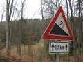
4 km of torture between Schönau and Grein

Friendly (Suffolk?) sheep
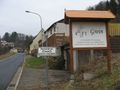
Entering Grein
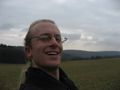
At the hashpoint (happy)
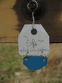
Tag on a fence near the hashpoint
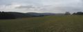
Into the gray wide open...


