2009-01-29 49 9
| Thu 29 Jan 2009 in Würzburg: 49.7677207, 9.7996902 geohashing.info google osm bing/os kml crox |
Location
Today's location is in the Probstforst ("provost's forest") next to Waldbrunn (de.wikipedia), not far from Würzburg. The hashpoint is in Bayern (EU:DE:BY) at an elevation of about 300m.
Expedition
Danatar
Finally a hashpoint in winter-cycling range! I started at 9:20 and took the road through the Steinbachtal. After that, I cycled through Erbachshof and Eisingen (ice-ingen, the common placename suffix -ingen is old Franconian and means something like "belongs to") to Waldbrunn. In Waldbrunn I took a wrong turn; I wasn't lost because I could always see the forest but the side streets left me zig-zagging up and down the hills. Once in the forest I used a small trail (not known to Google but to the Bavarian Land Survey Office) which led me directly to the hashpoint. I chose a beech tree (because of the smooth bark) to leave my chalk marks and rode home, this time using the correct road in Waldbrunn. Exhausted more than usual from all that slopes, I arrived back home at 11:30.
I cycled 16.3 + 15.7 = 32 km.
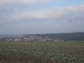
Waldbrunn and the Probstforst
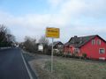
Waldbrunn town sign
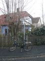
Last intersection before the hashpoint
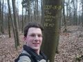
Coordinates reached


