2009-02-13 48 8
| Fri 13 Feb 2009 in Pforzheim: 48.4542140, 8.6897951 geohashing.info google osm bing/os kml crox |
Contents
[hide]Location
The hashpoint is at Horb, on a footpath in the Hohenberg residential area.
Hohenberg actually means "high mountain". The hash seems to be located at exactly 500 m above sea level, what, provided that it more or less marks the eastern margin of the Black Forest, isn't that high anyway.
Expedition by Ekorren
first approach by bike
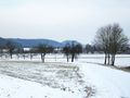
For more than two weeks the coordinates had mostly been located near the northern or southern graticule borders, or very close to the center, summarizing to the longest dry spell I had since I started to regularily go hashing. Add in that I had upgraded both camera and GPS since the last hash trip, I was quite eager to go. This one was a bit further than I'd have appreciated, but with an estimated distance of between 35 and 40 km one way and only acceptable slopes, and a wind forecast of not more than 3 Bft, it looked quite feasible.
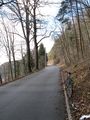
I started around 10:30 and went for the Neckar valley trail, taking the same direction as for the last hash I had visited before the break, which was 2009-01-28 48 8 at Bieringen. Due to headwinds, I was rather slow, but what's a headwind now would be a backwind in the afternoon, so it's not that bad. Bought some food at Rottenburg, continued west, and reached Bieringen around 12. From here I wanted to take a route over the Oberes Gäu plains, through Eckenweiler, Eutingen and Bildechingen, which is a bit longer and has some more slopes, but promised to be more interesting than the valley route I've been going a countless times before. Getting the impression that it wasn't only the headwinds that slowed me down, I stopped to raise the air pressure in the tyres (I had brought a pump).
The slope from the valley to the plains turned out not that nasty as I had feared. But once I got past the village, my bike started to make funny noises, and also something seemed to additionally brake a bit with each turn... maybe the brakes need readjusting? No, the brakes were ok... a loose screw? Nothing like that... just go on? Doesn't get better but worse...
And then I found what had happened: The back tyre was torn, and a blob had formed, hitting the bike frame with each turn. Damn. Can't go on.
As I didn't know of any bike shop nearby, the option to fix buy a new tyre and mount it on site wasn't applicable, so this expedition was to be called a failure. I just could hope it was secure to push the bike to the nearest train station. Luckily, that one would be quite near, as Bieringen has a station for itself, just on the other side of the valley. Carefully I lowered air pressure, and found that that reduced the blob size enough to get rid of the braking effect, and slowly went for the station.
Icy trail
Narrow trail
Neckar near Rottenburg
Not the destination, but the end
What & Where
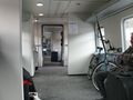
On the train


second approach by public transport
Around 12:45, I reached the train station and checked timetables. It turned out that there would be a train in about 20 minutes back home, or ten minutes earlier to Horb. Yes, just that Horb where the hash is. Well, and the hash should be in a larger residential area... another quick check of the map - yes, there will probably be buses up there. Also, it's just around noon, it's a nice and not at all too cold winter day, there is even some sun from time to time, I had planned to be out all day, so giving up maybe isn't the only option?
Fare check...
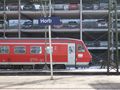
3,85 € to get from here to the hash, and then back to Eyach. The ticket from there home is the same as from here, so I'll have to pay that anyway. Way to go. So, instead of a ticket home, I bought one to Horb, and after a few minutes, heaved the bike into a class 611 DMU headed for hash town.
At Horb, I searched for a place to park my bike (the official bike parking at the station was occupied by a person I'd rather not trust), got timetable information for the way back, and went for the bus station to check the timetables at the various stops and finally found that there should be a bus to the Hohenberg area a few minutes later. A bus arrived, but it showed Isenburg in the display. That's the same line, opposite direction. Shouldn't be going just now. This bus going to Hohenberg? Sure Ah, ok, it's labeled Isenburg Oops, sorry! Gonna change that.
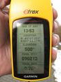
No, where to get off? I wasn't prepared to go by public transport at all - so I had no idea where the stops were located, neither I knew the name of the street where the hash was, and asking which stop to get off for N 48.4542140°, E 8.6897951° probably wouldn't result in any useful reply. All I had was some indication that this bus would take a circular line around the area which, at some point, should come quite near to the hash. So I sat down near the window, watched the GPS and as soon as the distance dropped below 300 m, signaled to get off at the next stop. From there, it was only a short walk.
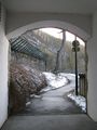
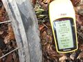
The hash itself was, as expected, on a footpath between houses. The people living just in front of the hash were actually coming home while I was making proof photos, and I didn't want to take any chance with them getting suspicious, so I kept the visit short and left. The place wasn't interesting at all anyway.
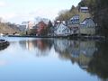
Now, I still had all of the afternoon, and Horb is worth a visit - so, I didn't go for the next bus back but took a long and nice walk into town, down a steep slope, along the old city walls, through the old town centre, down and up, up and down. Some impressions of this are below. Finally picked up the bike and took a train back home.
Train
Somewhere between these houses
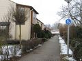
In front of this one
Coordinates
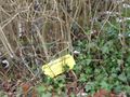
Marker
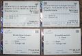
Needed four tickets


