2009-02-14 49 10
| Sat 14 Feb 2009 in Bamberg: 49.8253397, 10.1710255 geohashing.info google osm bing/os kml crox |
Location
Today's location is in a snow-covered young corn (cereal, not maize) field near Dettelbach's borough Neuses am Berg, at an elevation of 280 metres.
Country: Germany; state: Bayern (Bavaria, EU:DE:BY); administrative region: Unterfranken; district: Kitzingen
Weather (16:00): mostly clouded, 2°C
Expedition
Danatar
Finally a Saturday hashpoint in reachable distance (so far, only 3/31= <10% of my expeditions have been Saturday Meetups, instead of 14%). I started at 14:50 and used the by now well-known route to Dettelbach. The last 4 km were new for me and included a nasty slope. Due to a thin layer of snow (or muddy snow) on a large part of the track, it could not go as fast as usual, but I was only 200 m from the hashpoint when the Neuses church bell struck 4 pm. I did not trample the crops but stayed on the track 20 m from the hashpoint. On the return trip, there was nothing special.
Distance cycled: 21.7 + 21.7 = 43.4 km, 370 m uphill.
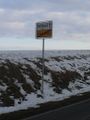
Neuses am Berg town sign

Coordinates reached
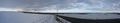
Red marker: hashpoint; White marker: 2009-02-11 hashpoint; Arrow 1: Grafenrheinfeld nuclear power plant steam; Arrow 2: Vogelsburg monastery near 2009-02-11 49 10


In the evening, I found out that I had forgotten my clock/thermometre in the snow near the hashpoint, where I had put it to let it adjust to the local temperature. Since it is my only (except for watch, cellphone and computer clock) clock, I absolutely had to get it back. On Sunday, I took the 10:09 train to Seligenstadt and cycled to the hashpoint. It was much colder than the day before, but I found the clock where I had left it. I cycled back to Seligenstadt and was in Würzburg at 11:51. Distance cycled: 21.5 km
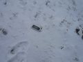
There it is, safe and sound. Maybe a bit lonely though...
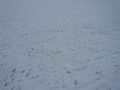
The hashpoint has been reached by hares, too.
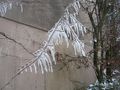
Ice-covered twig at Euerfeld.


