2009-03-01 48 8
| Sun 1 Mar 2009 in Pforzheim: 48.3552815, 8.9206630 geohashing.info google osm bing/os kml crox |
Contents
[hide]Location
The hash is located in a side valley at Hechingen, near the incorporated village of Weilheim.
Expedition by Ekorren
It wasn't a day where I actually wanted to go hashing at all. I had been on a hobby event the day before, still lacking one and a half night's sleep, and should probably have rested and cleaned up the worst of the mess the hasty preparation for that had left in my room.
Still, it was a day where one would want to go hashing. A day sunday isn't only a word on the calendar but an actual truth. It was actually the first expedition for months, where "frozen" wasn't an option at all. Rather, the forecast expected at least 10°C. Also, the coordinates were in a region where I hadn't gone hashing up to now, a beautiful area as well, and in a reasonable distance of 20 km as the bird flies. Provided that there is no such thing as flat terrain in this area, that would be about two hours one way by bike. A nice afternoon trip.
I started later than reasonable, but not too late - actually, it was around 13:00, so there would still be five hours of daylight. I chose the western Steinlach valley route via Dußlingen, Ofterdingen and Bodelshausen. Significant headwind slowed me down a bit, but as it was going uphill most of the time anyway, that didn't change too much.
Reaching Bodelshausen, the area became partly unknown to me, and seemingly also to the mapmakers of the topographic map. Some ways I had wanted to use were either non-existant or bare tractor tracks, and somehow I finally found myself going through a forest instead of through a village. Surprisingly that forest track still provided a reasonable way, and when I got into the hamlet of Oberhausen, I decided to use some spare time to map that for OSM. Which probably was a suspicious activity, because after passing a specific farm for the third time, an old woman stopped me to ask what I'm doing. Somehow I was glad that I only had to explain OSM to her, and not Geohashing. The terms "... one can use without needing to pay for..." always work with swabians anyway, and saying you come from Tübingen is like telling you come from another world for these people, so she would believe me. After a little bit of smalltalk I followed the signs of the Hohenzollern-Radweg touristical cycle trail.
I should have remembered that this specific trail isn't routed to actually reach any destination but to provide scenic views and pass historical sites. So it usually won't be a fast way to go, but taking unnecessary detours and failing to avoid hills. But the main reason why it turned out to be a bad idea was that the slope down to Stein was still covered in solid ice. I really hadn't expected that on a day where you can put off the sweatshirt because it's so warm. It's a strange feeling to go through ice and snow on such a warm day, really. Luckily, I already had gathered some experience in navigating ice tracks, so I somehow, very slow, reached the valley without falling. Passed a roman farm from the 2nd century, went through the village and for the last hill that still divided me and the hashpoint.
And again, there wouldn't be a way where I had expected it. Searching for some passable route to cross these damn fields, the detour got longer and longer, and finally I ended up pushing my bike through a mess of mud and water (which actually was labeled to be a hiking path) for hundred of metres, then reached a paved way which lead to a small castle. The current owners are a little bit concerned about their privacy, it seems, as most you could see of the castle was a collection of "No trespassing" signs.
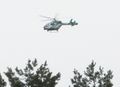
The last few hundred metres from here were easy. The point turned out to be at a very small creek in a meadow in a small side valley, with a view to the next village but not further. When I came there, a police helicopter arrived in the sky, and started to circle around the area. I watched it for some time, wondering whether they were watching me (actually, there isn't so much to watch in that area...). They didn't leave while I was there, but neither they came down to let me ask.
After some time of watching the helicopter and making the obligatory photos I set for the way back. It was now much later than planned, so I should probably go for a fast route on definitely paved and existing ways. There seemed to be two of them: Either through Hechingen and the Steinlach valley, or via Rangendingen and Hirrlingen into the Neckar valley. I chose the latter, as it wouldn't require me to go much up that hill again just now.
Somehow, after all those slopes, mud tracks, and ice roads, I was exhausted. My legs demanded a significant break, my stomach demanded some food, the bike headlight demanded new batteries, the coming twilight demanded to at least reach known areas as fast as possible. Any reasonable person would probably go for a train station and return by train now. And it wasn't before Rangendingen that I realized that I just had chosen a route that featured a good number of additional nasty hills along the way, no possibility to get a fast carbohydrate fix, and would not even come near an active train station.
So, by the time I finally reached home, I was really exhausted.
Gallery
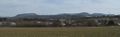
The Albtrauf around Mössingen

Lindich castle
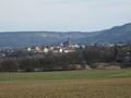
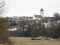
A view on Hechingen
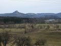
Castle Hohenzollern is the most famous tourist attraction of the area
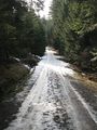
No, I hadn't expected any more ice covered tracks...
The hashpoint is at the small creek
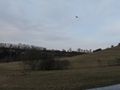
Policemen doing an air hash?
Scale 1:1, not RC.
Today's hash village: Weilheim

Who are you and what are you doing at my farm?
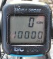
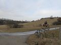
Bike km counter reached a round number shortly after departure
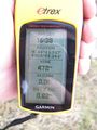
Proof


