2009-03-02 -34 150
| Mon 2 Mar 2009 in -34,150: -34.0685631, 150.7770379 geohashing.info google osm bing/os kml crox |
Contents
[hide]Location
This hashpoint was located inside the Mt Annan Botanic Gardens. It was over the back of the Gardens well and truly off the main walking tracks.
Attendees
CJ earned the Land geohash achievement
|
CJ earned the Admit One Achievement
|
Report
This geohash fell right towards the Northern end of the graticule, which meant it would be easily accessible from Sydney. By complete chance I actually had to visit a colleague who lived only 10 minutes from the hash location. It was time to try and successfully conquer the Wollongong graticule!
The actual hashpoint fell within the Mt Annan Botanic Gardens which I had never visited, but they looked to be quite nice from their website. I noted that it would cost $9 for admission (hooray for Admit One Geohash), and that the Gardens closed at 5pm. Suddenly I realised that this was going to make things interesting as I estimated that the earliest I would be able to get to the Gardens would be around 4.30pm. This would mean I wouldn't have all that long to get my car as close as I could to the point; walk what looked like a few hundred metres on the satellite map; walk back to the car; and get out of the park before the gates closed. Still - I was going down that way anyway so it was worth a shot.
Travelling down south towards the location I got stuck in a few areas of heavy traffic, and began to think that I was not going to have enough time to get in to the park, complete the hash, and get out again. Fortunately though once I hit the freeway things cleared up and I seemed to make up the lost time. In the end my estimations had been pretty accurate, and I arrived at the Gardens right on 4.30pm. The lady at the entrance looked quizzically at me as I handed over my $9, and emphasised that the gates would be locked in half an hour.
I eventually navigated my way around to what seemed to be the closest point I could get my car and parked it on the side of the little roadway. I looked over in the direction of the hashpoint, and realised that yet again I had completely forgotten that the world isn't quite as flat as the Google satellite images may make it seem. It's not that there were steep cliffs or anything, just quite a few hills, and some rather dense looking bush that would make things interesting. Normally this wouldn't have bothered me, but I was conscious that this was a race against the clock.
I grabbed the camera and the map, locked the car, and set off. I had 20 minutes to be back at the car again. I headed off up over the first hill through what I soon discovered was quite long grass. Due to it being a hot afternoon I was wearing shorts. Bare legs and long thorny grass don't go well together. But right now that wasn't my concern. I had to be quick.
I soon discovered something had gone through the grass recently making tracks I could follow (which were hopefully snake-free). Coming around a clump of trees I startled a few wild kangaroos who quickly hopped off. I realised it was their tracks through the grass that I had been following. Once I reached the top of the ridge I came across a well defined path (just as I had been expecting from the map). I needed to check the time. Oh no. Where was my phone? In the rush to head off from the car, I had left it sitting next to the driver's seat. It was my only way of knowing the time. Now I was not only in a hurry, but I also had no idea of how much of a hurry I was in. Still - this was geohashing, and I had to press on.
Walking along the track to the right point I soon realised that this hash was going to be very difficult to reach. Between myself and the hashpoint lay a steep downhill incline covered in very dense bush. It seemed I had been defeated. Gazing at the general area I made a quick decision. I was going to go for it anyway. So I set off down the incline, half running, half sliding down the hill. Going towards the point I was slowly making progress. I estimated that I was now probably only 50 metres from the right spot.
But then another problem - dense, dense bush. A wall of bush that was blocking my way. I coudn't see any way to get through. Based on time estimates I knew I really needed to turn back if I was going to get out. Defeated. Again. Or was I? In a moment of unexplainable craziness (which I like to call 'geohashing brain') I just started running. Not away from the impassible bushland, but right into it. I blindly plundered through trees and shrubs, over logs, and trying not to fall into the wombat holes. I honestly have no idea what made me do this - except for the desire not to be defeated by this graticule again. After a few minutes I came into an area of semi-clearing.
I looked at the map. I looked at everything around me. Who would have thought - I had run right to the exact hashpoint location! Now time was really of urgency, so I took a few quick pics, and realised I had to get back through the bush, back over the hill, and back to my car pretty quickly. I had no idea how long I had left, but it would definitely would have to be a quicker trip back than it was to get here.
So once again I set off ploughing through the bush, back up the steep incline to the top of the ridge. To my surprise I could see my car just down the slope via a much quicker route than the one which I had taken on the first leg of the journey. I raced down the hill through the long grass, scaring more wild kangaroos as I went. Eventually I back to the car - hot, sweaty, and puffing. I had done it, but what was the time? Was I going to be locked in? Finding my phone, it was only 4.55pm! Just enough time to drive back to the entrance and get out.
Now that is what geohashing is all about!
Photos
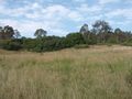
The view from where I left the car
I came across wild kangaroos
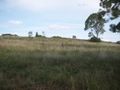
The track at the top of the ridge
The hashpoint was somewhere down this incline
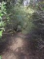
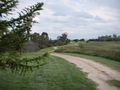
At least there was a track at this part
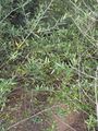
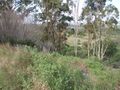
The bush was getting thicker (it got much worse than this)

Compulsory grin at the hashpoint
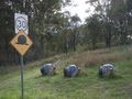
Snails crossing?

Thanks for coming!
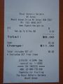
Proof of entry for Admit One Geohash


