2009-03-04 global
|
Globalhash on Wed 4 Mar 2009: |
Contents
[hide]Planning
What are the odds... the globalhash point is one graticule south, and I am without a GPS while my geocaching friends are out of town for spring break. I will do everything possible to find a GPS before I set out around 10 in the morning. Otherwise, looks like it'll be a no-batteries globalhash... many pictures will be taken, either way. Tremendous thanks to starbird for the encouragement!
http://www.drwilco.net/globalhash/map.html?date=2009-03-04
Participants
Trip
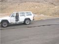
No friends. No GPS. One man, alone against mother nature, with only his trusty Jeep Cherokee to ferry him to the world's first globalhash...
The Route
The Plan
Leave Billings between 10 and 11 am. Arrive in Lovell around 12. Summit the US-14 pass around 12:30, and the hash point by 1.
The Experience
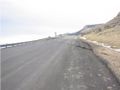
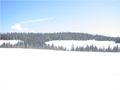
Everything went well until the road itself. I left Billings after filling up around 10:45, and was in Lovell by noon. The road along US-14 has a couple Bentonite mines, which I noted as worth exploring on Wikipedia upon my return (it's a clay with aluminum, and is useful in oil and natural gas drilling). About 18 miles out of Lovell, at the base of the Big Horn mountains, was the first sign of trouble:

This is a national recreation area, and I am clearly a winter recreator. Clearly, no one was coming down, so I could do whatever I please (respectfully, of course). The next sign was a more oblique premonition...
Road Damage

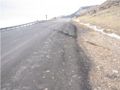
"What? Of course not. No Montana roads are bad." Oops. I'm in Wyoming.
I've driven unmaintained gravel roads in better condition.


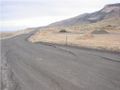
Continuing on, the road is fine for another 6-8 miles. "This isn't bad. Hairpin turns are nothing where I'm from!" Mother nature wasn't happy with such arrogance. She decided that was enough from me.
Road Closed


After checking my maps and odometer, I determined I was about a mile from the Sheep Mountain Road intersection that Google Maps told me I needed to take. I decided to hike the mile, to see the terrain and snow. The snowpack on the road itself was between 3 inches and a foot, though there were a couple bare spots. The road itself was well backed by snow cats and snowmobiles, and I figured my jeep would do just fine, and wouldn't need either 4-wheel drive or chains. At least, it would do US-14 fine. I couldn't find the side roads. They must all be gravel tracks, and none were visible beneath the snow. As they say, the harder you get stuck... the harder it is to get unstuck.
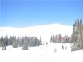
Note the road marker sticking 9 inches above the snow...


"My kingdom for [a horse|snowshoes|a dogsled team|a snowmobile]". Clearly, there was no way my jeep could make the 8 miles, and neither could I. Further, I'd probably get lost. Alas, I am mother nature's bitch. On my way out, I did run into some woodsman with a snowcat. Alas, they were heading south from the road, not 8 miles north. "Sorry, I need to go 8 miles due north." "Why?" "I'm from the internet." It was a good discussion, ending in me giving them the URL for the Main Page.

Consolations?
This user earned the Done with Nature consolation prize
|
Not to give up, the geohash for my home graticule was on the way home!
https://geohashing.info/s/2009-03-04/45,-109
Google maps is a dirty whore. Silesia road no longer extends south, and instead ends in a ranch farmyard.

But there were baby animals.

The Moral
While many people might be disappointed with two failed activities in a day, that's not how us Geohashers see things. I got to see some beautiful country in the Big Horn mountains that I would otherwise not have seen, and I have a good excuse to go back for some camping this summer. I met some baby animals (always cute!). All in all, today was a great day, and I'm content with getting 8 miles from a Globalhash. They're a lot harder than any might expect. OTOH, no goofy grin photos were earned.
Life Lessons
- Google Maps is serious when they say "check road closures",
- Google Maps is not good for rural areas.
- Google Maps is good at giving false confidence.
- David Souther needs a GPS.
- David Souther need [a horse|snowshoes|a dogsled team|a snowmobile].