2009-03-08 48 8
| Sun 8 Mar 2009 in Pforzheim: 48.5792666, 8.9768719 geohashing.info google osm bing/os kml crox |
Contents
[hide]Location
The hash is located near Breitenholz, Ammerbuch municipality, in the Schönbuch forest area. It appears to be somewhere in a game reserve area.
Expedition by Ekorren
It was another one of those "too close not to try" locations: Less than 10 km as the bird flies. However, distances "as the bird flies" aren't very meaningful in a mountainous forest area. The weather forecast was very discouraging, it should get cold, rainy and windy during the afternoon. Also, in yesterday's newspaper, authorities recommended to avoid the higher parts of the forest because of a risk of trees breaking under the weight of wet snow. However, I had been to the city margins the day before and checked out the snow conditions up to 500m, so I believed to be able to estimate what I had to expect in the forest, and dangerous amounts of snow on the trees was not among that.
There were two reasonable routes to get to the hash. Either go through the Ammer valley, which would be an easy, straightforward and mostly flat paved trail to Breitenholz, from there up into the mountains to about 530 m above sea level, and approach the hash from above. Or take the Goldersbach valley trail, which would probably be a bit longer and go mostly through the forest, being not less straightforward, and approach from below.
Around town on the day before there was an almost clear snow margin - below of about 450 m, there were some remains at most, above, there was too much of it. There hadn't been any new snowfall since then, so counting everything together it seemed to be a good idea to approach from below, and do so not too late. So, around noon I got on my bike and went off for the forest trail.
The trail was mostly clear and I reached the famous monastery of Bebenhausen, a #1 tourist attraction, where the valley narrows and the road leaves it. Although I was still well below 400 m, some snow was even left on the track here, but it wasn't a problem - yet. About one hour after leaving, I reached an intersection called Teufelsbrücke (devil's bridge). This is where most of the people turn around, also where the trail splits up for the second time - that is: From here it's considerably less travelled. Also, it goes up. And in that narrow valley, doesn't get much sun during the day. So you might have guessed it: There was snow.
A nasty kind of snow it was, also. Wet, heavy, sticky. Stay in the line some tractor has made, or you'll get stuck. From time to time you'll get stuck anyway, then stop, push the bike until it gets better, get on again. Well, only a few km to go, so don't give up.
I knew the area. More or less. Have passed through here a number of times in non-snowy seasons. Ok, and here I should probably leave the main track to the left and go up... and get stuck. Hrm. Well, get out the GPS, how far is it anyway? Still 1,85 km. Er... no. This wasn't the right intersection. Well, technically it was, because there was a shortcut on the map. But given that shortcut looked quite unpassable... back to the main track, for now.
Next intersection... 1.00 km from here. Yeah, that sounds better. Now, there wouldn't be a choice - this is the way I have to take. Up here, push the bike, carry it, whatever - but go up. And at some point, there will be a way to the right leading to the hash. Or maybe not. Wasn't really clear on the maps.
There was. Only it was in even worse condition, and lead - into a deer feeding facility. Forbidden to enter, impossible to get around. Ironically, the sign which said that you must not approach the facility closer than 100 m was located so that, at the point where you could read it, you already were closer. But still 400m from the hash, with the only track that might possibly lead into the right direction going right through the feeding place, and no indication whether it would even continue at the other side.
So I called that a failure: No trespassing. Still, the approach from above was still in the run, after taking the through track to get around the game reserve. Judging by the map, that track would also come near to the hash by about 200, maybe 300 m. Quite far for a snowy cross-forest walk, but worth a try.
Well, not worth a try, really. Getting higher in elevation, the snow conditions got even worse. It wasn't much of a slope. It was getting stuck every few metres, more pushing than cycling, balancing, getting on and off the bike, getting stuck again. Less than pedestrians speed in average, but walking wouldn't have been much easier. The distance to the hash was insignificant anyway, as it turned out that it was on the other side of a small canyon.
So, my last chance would be to get to the peak point from where a track was supposed to go down into the area of the hash. Somehow, I reached it.
Well, there was a track, or was there? It was hard to judge. It was entirely covered by a thick layer of that glue that's called snow. Nothing had passed it for days, or even longer. And still almost 600 m to go. Downhill. And up again. And no idea whether what somehow looks like a way from here will continue at all after a hundred metres or so, and whether it will lead to the hash. Maybe it does. But not with the given amount of snow. Not after all that balancing myself through that white mayhem, racing a distance of 10 km in speedy 1:40 hours. Yes, that's a 7 km/h average and not at all bad for today. Not when it just gets colder, dark clouds arise in the sky, and you know that the forecast expects the weather to get really ugly some time soon.
Going back the same way wasn't really an option, getting out of that forest was what counts. So I went for the track which would lead down on the side. And, after only a few more minutes, the track got better, leading down again. There was the Ammer valley. And it was green.
Gallery
Riddle for our german readers: You probably do know that woman's picture. Do you also recognize it?
Monastery of Bebenhausen
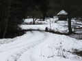
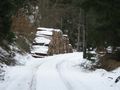
Just an impression on the way
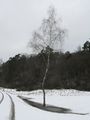
And now for something completely different: Snow!
After all, winter forests are beautiful.
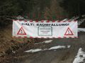
STOP! TREECUTTING!
Mortal danger
No Trespassing
§37 section 4 sentence 4 State Forest Law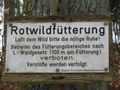
Deer feeding
Please grant the game the necessary rest!
Forbidden to enter the feeding area according to state forest law (100 m around feeding place)
Violation is prosecuted
State Forest Office Bebenhausen
Game rest area
Forbidden to leave paved ways
§38 section 1 state forest law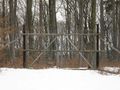
It's actually allowed to pass this gate. Just not very recommendable today.
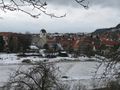
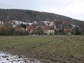
Today's hash village: Breitenholz
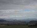
A view on the Ammer valley, Wurmlingen Chapel, and Albtrauf.


Tracklog
...is here. Includes a detour via Reusten for geocaching.