2009-03-14 48 9
| Sat 14 Mar 2009 in Stuttgart, Germany: 48.5407367, 9.1119046 geohashing.info google osm bing/os kml crox |
Contents
About
The hashpoint is on a meadow at the slope from Pfrondorf (Tübingen municipality) down into the Neckar valley. It seems only to be accessible from above, as there are probably no ways up the steep slope through the forest below. Most agricultural tracks shown in google maps also don't exist in that area.
Expedition: Ekorren
How often did you curse the coordinates, the weather, lack of time, wrong day? Well, me too. And so I was really surprised when the coordinates for this saturday came out - only 5.4 km from home as the bird flies, and the weather forecast expected a rather warm and dry afternoon, which would make a strong difference from the cold, windy and wet days we had so many of in the last few weeks. This hash was so near perfect, that it was no question that it should make for some of the more difficult achievements. I had considered the midnight hash first, but then reconsidered because I didn't want to waste the opportunity for a centurion point, and also there was a hash not far from there where I almost had met someone on the saturday 4 pm time. You never know, that might work again. So, 4 pm it was.
Go by bike? Well, that wouldn't be any special. Time wasn't much of an issue either. Walking? Hmmm... quite a distance. But feasible. And there probably won't be a nearer one any time soon. So, walking it was.
I expected the walk to take about one and a half hour one way without breaks, but didn't want to need to hurry more than necessary. So I set off around 14:00.
First, I met my mother on the street. Hello, where are you going? Er... oh, walking? er, yes ? Well, you remember? I told you about that last year, and there is that special if you go by various transport, and I haven't done one by foot yet... also, it's a nice day, so I didn't want to stay at home if I can help it. So, where? Pfrondorf. ah ok, that's doable... have a nice walk. Thanks...
... and on I went, along the Neckar river, crossed the river at the 98 year old power plant, and went for the village of Lustnau and up the mountainside.
Where suddenly someone called me. Hey, D...! Oh, on foot today? Why that? Yes... There's a reason. ? yes, no, my bike isn't broken. Ok, mine is... you see, I'm taking the small one today. It's no fun to go up to Pfrondorf with that one. But can't help it, I'm living there. Well, you know why I'm glad to live in the valley...
From the bicyclist-smalltalk that followed I learned that a specific less-known track to Pfrondorf has only 9% of inclination compared to 12% on the recommended route. Need to remember that. There might be more hashes up there. After all, I didn't need to explain geohashing this time. He probably wouldn't have understood a word.
Now, I crossed Lustnau on rather uncommon footpaths, through the graveyard and a new residential area. According to the map, there could be a way through the forest providing a shortcut, but the one I found didn't it. So, after a small detour through the forest I was almost back at the same place. Finally found something that wasn't exactly a way, but neither it was exactly no way, and also it went right into the correct bearing, so I switched to cross country mode and climbed over the logs that blocked it. Came out on a meadow, jumped over a small creek and was soon back on paved ways. On the very track that would come nearest to the hash, even.
When approaching the area, I started to fear that I wouldn't be able to reach the point - it was all meadows, yes, but a ridiculous number of those meadows were actually fenced. The nearer I got, the more likely it seemed that the point was in a fenced area. But just at the place where the arrow on the GPS went to 90° from the track, the fence ended. After a short look around to check whether someone of those many hobby gardeners around was looking (you never know with suabians, they might call the police just for stepping on a meadow, no matter that that generally is allowed), I walked down into the wet and muddy meadow.
Arrived at the hash at 15:50. It was just outside of a fenced area, less than five metres from the fence. Phew.
While staying at the hash, a repeating creaking noise startled me. An animal? But what kind of animal would be able to make such a noise? A haunted house? But there is no house here? I started to investigate, and found that the noise was coming from a tree very near. And then also found the reason for the noise: A large branch had broken off, but didn't fall to the ground - but instead it lay on another branch, perfectly balanced, gently swinging back and forth, up and down, in the wind. Er... let's better keep a secure distance from that tree...
I waited until 16:15, just in case someone else would show up, then took my stuff and started on the long walk back home. Took a small (well, it got larger because of non-existant ways) detour to visit a nice viewpoint I remembered from an earlier visit, another one to get around that forest from before (now, after almost fully circling it, I'm sure the way shown on the map does not exist at all), and went for the city centre. I had a slight hope to find a postcard that would be valid as a hashcard, but all I found were from the centre, none showed any part of Pfrondorf. Finally reached home again at 18:50 and was surprised to find that that had been the longest walk expedition so far.
Hey, you can do better than that. 16 km aren't that much anyway. Seriously.
Gallery
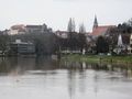
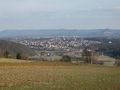
This is my town
Lustnau, the suburb I had to pass
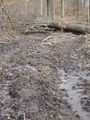
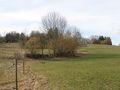
The map claimed there is a way somewhere
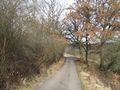
This way to the hash
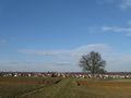
It's somewhere down there. The village in the background was host to 2008-11-15 48 9.
View from hash
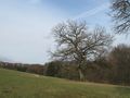
Another view from hash
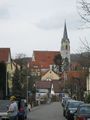
Today's hash village: Pfrondorf
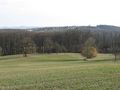
A view into the Neckar valley
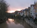
Sunset in the inner city
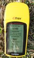
The (un?)avoidable proof photo


Tracklog
... is here.
Note: The log is stripped of the first and last part and the actual search for a mystery geocache, gaps are filled with straight lines.
Ekorren earned the Walk geohash Achievement
|