2009-03-15 -36 144
| Sun 15 Mar 2009 in -36,144: -36.6810282, 144.4051872 geohashing.info google osm bing/os kml crox |
Contents
The location
Near the edge of the Wellsford Forest, outside Bendigo.
Who will go?
myka
The Plan
Should be about a 17Km ride each way, around the city centre, then out towards Epsom and along the back-route out of town to the north. From memory there is only one hill of note, in Ascot, and it's quite manageable.
Due to me being the only known hasher in the area, (this will be a virgin graticule if I make it, and I'm the only known person to attempt an expedition here in the past), and the fact that I need to catch a train back to Melbourne later in the day, I'm not worrying so much about getting there at 4:00 (also, its a Sunday).
Who Went?
myka
Started out about 13:00. the ride around town was easy and nice, however as soon as I'd gone 50m I realised the error of my thoughts about hills... I'd completely forgotten that my Mum's place was in fact on top of a hill, pretty much, and the very end of the ride today may be a little fun, depending on which way I finished the trip.
Once again I'm reminded of just how nice and wide the streets in Bendigo are. Many have huge amounts of space available. Most are a joy to ride on after riding around on Melbourne streets. (the traffic is better too of course).
I took the back (kind of) route out to the north of the city. One used fairly commonly when starting trips out of the city to the north, at least from that half of town. I joined the Midland Highway (main northerly road out of town) briefly to get to Epsom and my turn-off towards Fosterville. Once again on the back-route, I happily discovered that the one hill I had thought of was indeed smaller than I remembered. but then I'd never climbed it outside a car before, so the bad memory is un-surprising.
The ride from Ascot towards Fosterville was very pleasant, being pretty flat, and mostly through the Bendigo State Forest. I was also quite happy to find out that the intersection I was looking to turn off at was much closer than I remembered. A last Kilometre or so took me to the edge of the Wellsford forest (correct name?). From there the hash point was a short way up a dirt side road, then about 500m into the forest itself.
I was wondering how far I would get on the bike, due to my lack of full off-road tyres, but figured I'd see how it was. The dirt road was pretty good, being hard-compacted with only a thin layer or gravel (and mostly distributed away from the car tyre zones). When I'd had a look using google maps earlier in the day, there appeared to be some sort of track leading up beside the last property, going about half-way to the hash-point before turning and heading off in another direction. I found the track pretty easily, but where I had been expecting a car track, what I found was a bike / walking trail. Never Mind, It was still clear and pretty safe for my bike. I headed on up it until I found the turn where I would need to leave it and journey (a whole 250m!) off on my own.
Once again I had to think about my bike. the ground in there area is flat enough, but covered with potential puncture inflicting items, from broken (and breakable) sticks, to sharp rocks, and the occasional bits of broken glass or tin. I decided to risk it, and ride slowly and carefully. I could use animal trails to keep to places where the potential dangers were more visible. Also, I checked the GPS for a heading, then set off.
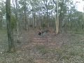
The combination of using animal tracks and avoiding sharp things, as well as getting used to using the GPS meant I circled the Hash-point about 3 or 4 times, within about 20m of it, before actually finding it. But find it I did! I parked my bike on the random piece of hash-ground, near a few trees, and felt happy.
My newly designated Hashscot made an appearance at this point, looked at the view from my bike, and then celebrated the large XKCD I wrote on the ground with a stick. The forest was pretty typical of the ones in central Victoria, being dry, open and not very undergrowthy. Generally fairly easy terrain.
Shortly after that I found evidence of Velociraptor activity in the area, and decided it was time to leave, for the safety of me and the Hash-scot.
The return journey was not quite as pleasant as the outward one. Tricksie Mother Nature had been lulling me into a false sense of pleasantness, and now showed her hand. that nice ride out of ascot turned out to have been slightly downhill, so I now had more than 5km of (admittedly gentle) uphill, with the now activated easterlyish Headwind of Great Annoyance. While not exactly overwhelming, the combination of factors added greatly to the amount of effort required to get back to town.
Finally back on the Highway, I got to turn side-on to the wind, at which point it attempted (mostly unsuccessfully) to rain on me. I Thought about the last part of the trip, and decided that the best way home would be to ride straight through the centre of town, and then turn up to the house by my old High School. Then I figured I might as well take some photo's of the City itself, as it's not an unpleasant looking place, and people might be interested.
It's a very weird feeling acting touristy in your own hometown, I must say.
I stopped at Lake Waroona and saw swans. Passed the Talking tram, and decided to stop in at the Golden Dragon Chinese Museum, where Sun Loong the Imperial dragon sleeps most of the year. (He is woken up for the Bendigo Easter Festival every year).
I was happy to wander through the Chinese Gardens, and the (activly used) Temple, which celebrate the part played by the Chinese community in Bendigo's History, and was impressed by the contents of the Museum, which aside from Sun Loong and his predecessor Loong, is full of some pretty impressive Chinese artifacts. Unfortunately the lighting was bad for my camera phone, and the photos I took are mostly a bit artifacty (pun not intended - shush you.).
The last bit of riding through the City was uneventful. the Hill at the end was fine. The dog I was looking after for the weekend was happy to see me.
I had taken a few shots of some of Bendigo's landmarks as I rode through town, but the dismal light from the now overcast skies did not make my camera-phone happy, so instead I'll just point out the Wikipedia page, which has better photo's by a long shot.
Now if only I can find the cable for the GPS I may be able to add at least a little bit of info to the (totally dismal) OSM map of Bendigo.
(Ok, so I am exaggerating / using artistic licence a little about how difficult it was, but the wind was gusting up to over 40Km/h, in the area, during parts of my ride, in exactly the wrong direction)
20.13Km there, ~18km back. 38.65 Km total
mykaDragonBlue earned the Graticule Unlocked Achievement
|
mykaDragonBlue earned the Bicycle geohash achievement
|
mykaDragonBlue achieved level 1 of the Minesweeper Geohash achievement
|
Photos
myka
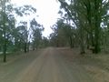
Dirt Road: the path into the forest is just up on the left.
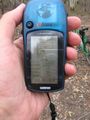
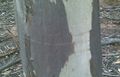
It's alot easier to read the proof with a proper camera.

It was windy in places.
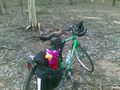
My newly Designated hashscot and bike at the hash point.
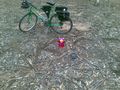
Celebrations of a marker.
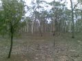
This type or forest...
...is pretty open and easy terrain.
Signs of Velociraptor activity in the area.
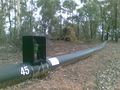
This pipeline follows the road for kilometres.
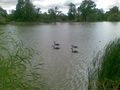
Swans at Lake Waroona
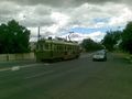
The Talking Tram
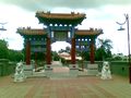
Entrance to the Chinese Museum precinct.
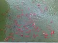
Koi(?) in the Chinese Gardens
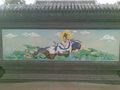
Paintings in the Temple entrance way
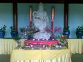
Kuan Yin (The Goddess of Mercy)
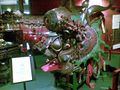
Loong, Predecessor of Sun Loong, the current dragon.


Photo's from the camera I borrowed (which ran out of batteries at the Hash point) may make it up later.